, from the Canadian city of Sarnia, Ontario (right), and enters into Lake Huron in this photograph from the International Space Station as it orbited 263 miles above.")
WIKIARCHIVES.SPACE
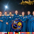
The Human Spaceflight Archive


Information
- Taken in
- Space
- Author
- NASA
- Description
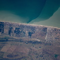
- The St. Clair River separates the American city of Port Huron, Michigan (left), from the Canadian city of Sarnia, Ontario (right), and enters into Lake Huron in this photograph from the International Space Station as it orbited 263 miles above.
- Created on
- Wednesday 16 August 2023
- Albums
- ISS (WIP) / EXPEDITIONS / EXPEDITION 69
- Source link
- https://www.flickr.com/photos/nasa2explore/albums/72177720303913632
- Visits
- 16
- Rating score
- no rate
- Rate this photo
- License
- CC BY-NC-ND
- Modified by WikiArchives
- No (original)
- Downloads
- 0
EXIF Metadata
NIKON CORPORATION NIKON D5
- Make
- NIKON CORPORATION
- Model
- NIKON D5
- DateTimeOriginal
- 2023:08:16 12:58:40
- ApertureFNumber
- f/8.0
Powered by Piwigo