
WIKIARCHIVES.SPACE
The Human Spaceflight Archive
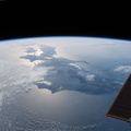
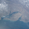
The southeast geography of the state of Massachusetts including Cape Cod Bay, Martha's Vineyard, Nantucket and the arm-shaped peninsula is clearly seen from the International Space Station as it orbited over the Atlantic coast of the United States.


Information
- Taken in
- Space
- Author
- NASA
- Description
-
The southeast geography of the state of Massachusetts including Cape Cod Bay, Martha's Vineyard, Nantucket and the arm-shaped peninsula is clearly seen from the International Space Station as it orbited over the Atlantic coast of the United States.
- Created on
- Saturday 14 April 2018
- Albums
- ISS (WIP) / EXPEDITIONS / EXPEDITION 55
- Source link
- https://www.flickr.com/photos/nasa2explore/albums/72157679671299912
- Visits
- 17
- Rating score
- no rate
- Rate this photo
- License
- CC BY-NC-ND
- Modified by WikiArchives
- No (original)
- Downloads
- 0
EXIF Metadata
NIKON CORPORATION NIKON D5
- Make
- NIKON CORPORATION
- Model
- NIKON D5
- DateTimeOriginal
- 2018:04:14 16:19:45
- ApertureFNumber
- f/20.0
Powered by Piwigo