
WIKIARCHIVES.SPACE
The Human Spaceflight Archive


Information
- Taken in
- Space
- Author
- NASA
- Description
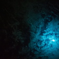
- What at first glance might appear to be a piece of abstract art is actually a photo made using a 180mm lens from approximately 226 nautical miles above Earth featuring the very wide Amazon River floodplain at Santarem, Brazil. One of the Expedition 37 crew members aboard the International Space Station took the photograph on Sept. 18, 2013. Center coordinates of the area pictured are located at approximately 2.1 degrees south latitude and 54.9 degrees west longitude.
- Created on
- Wednesday 18 September 2013
- Albums
- ISS (WIP) / EXPEDITIONS / EXPEDITION 37
- Source link
- https://www.flickr.com/photos/nasa2explore/albums/72157631323322922
- Visits
- 24
- Rating score
- no rate
- Rate this photo
- License
- CC BY-NC-ND
- Modified by WikiArchives
- No (original)
- Downloads
- 0
EXIF Metadata
NIKON CORPORATION NIKON D3S
- Make
- NIKON CORPORATION
- Model
- NIKON D3S
- DateTimeOriginal
- 2013:09:18 16:11:11
- ApertureFNumber
- f/11.0
Powered by Piwigo