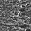
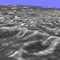
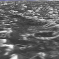
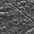
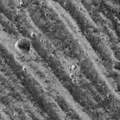
 with a resolution of 76 meters. The other was taken September 6, 1996 at a range of 10,220 kilometers (about 6,350 miles) with a resolution of 86 meters. The topographic nature of the deep furrows and impact craters that cover this portion of Ganymede is apparent. The blue-sky horizon is artificial.
The Galileo mission is managed by the Jet Propulsion Laboratory for NASA's Office of Space Science, Washington, D.C.")
WIKIARCHIVES.SPACE
The Human Spaceflight Archive
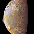
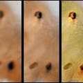
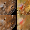
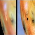
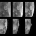
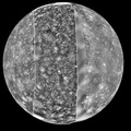
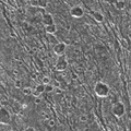
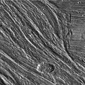
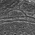
Topographic detail is seen in this stereoscopic view of the Galileo Regio region of Jupiter's moon Ganymede. The picture is a computer reconstruction from two images taken by NASA's Galileo spacecraft this summer. One image of the Galileo Regio region was taken June 27, 1996, at a range of 9,515 kilometers (about 5,685 miles) with a resolution of 76 meters. The other was taken September 6, 1996 at a range of 10,220 kilometers (about 6,350 miles) with a resolution of 86 meters. The topographic nature of the deep furrows and impact craters that cover this portion of Ganymede is apparent. The blue-sky horizon is artificial.


Information
- Taken in
- Tác giả
- NASA/JPL-Caltech
- Miêu tả
-
Topographic detail is seen in this stereoscopic view of the Galileo Regio region of Jupiter's moon Ganymede. The picture is a computer reconstruction from two images taken by NASA's Galileo spacecraft this summer. One image of the Galileo Regio region was taken June 27, 1996, at a range of 9,515 kilometers (about 5,685 miles) with a resolution of 76 meters. The other was taken September 6, 1996 at a range of 10,220 kilometers (about 6,350 miles) with a resolution of 86 meters. The topographic nature of the deep furrows and impact craters that cover this portion of Ganymede is apparent. The blue-sky horizon is artificial.
The Galileo mission is managed by the Jet Propulsion Laboratory for NASA's Office of Space Science, Washington, D.C.
- Khởi tạo vào
- Thứ Ba 18 Tháng Mười Một 1997
- Đề mục
- US SPACE PROGRAM / PROBES / JUPITER / GALILEO / Mission Photos (Edited) / JUPITER / GANYMEDE
- Source link
- https://photojournal.jpl.nasa.gov
- Thăm quan
- 19
- Bảng xếp hạng
- không có đánh giá
- Đánh giá hình này
- License
- Public Domain
- Modified by WikiArchives
- No (original)
- Tải xuống
- 0
Sản phẩm của Piwigo