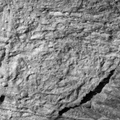
 in diameter. The large number of craters seen here is unusual for Europa. This section of Conamara Chaos lies inside a bright ray of material which was ejected by the large impact crater, Pwyll, 1000 kilometers (620 miles) to the south. The presence of craters within the bright ray suggests that many are secondaries which formed from chunks of material that were thrown out by the enormous energy of the impact which formed Pwyll.
North is to the upper right of the picture and the sun illuminates the surface from the east. The image, centered at 9 degrees latitude and 274 degrees longitude, covers an area approximately 8 by 4 kilometers (5 by 2.5 miles). The finest details that can be discerned in this picture are about 20 meters (66 feet) across. The images were taken on December 16, 1997 at a range of 960 kilometers (590 miles) by the Solid State Imaging (SSI) system on NASA's Galileo spacecraft.
The Jet Propulsion Laboratory, Pasadena, CA manages the Galileo mission for NASA's Office of Space Science, Washington, DC. JPL is an operating division of California Institute of Technology (Caltech).")
WIKIARCHIVES.SPACE
The Human Spaceflight Archive
This high resolution view of the Conamara Chaos region on Jupiter's icy moon, Europa, reveals craters which range in size from about 30 meters to over 450 meters (slightly over a quarter of a mile) in diameter. The large number of craters seen here is unusual for Europa. This section of Conamara Chaos lies inside a bright ray of material which was ejected by the large impact crater, Pwyll, 1000 kilometers (620 miles) to the south. The presence of craters within the bright ray suggests that many are secondaries which formed from chunks of material that were thrown out by the enormous energy of the impact which formed Pwyll.


Information
- Taken in
- Author
- NASA/JPL-Caltech
- Description
-
This high resolution view of the Conamara Chaos region on Jupiter's icy moon, Europa, reveals craters which range in size from about 30 meters to over 450 meters (slightly over a quarter of a mile) in diameter. The large number of craters seen here is unusual for Europa. This section of Conamara Chaos lies inside a bright ray of material which was ejected by the large impact crater, Pwyll, 1000 kilometers (620 miles) to the south. The presence of craters within the bright ray suggests that many are secondaries which formed from chunks of material that were thrown out by the enormous energy of the impact which formed Pwyll.
North is to the upper right of the picture and the sun illuminates the surface from the east. The image, centered at 9 degrees latitude and 274 degrees longitude, covers an area approximately 8 by 4 kilometers (5 by 2.5 miles). The finest details that can be discerned in this picture are about 20 meters (66 feet) across. The images were taken on December 16, 1997 at a range of 960 kilometers (590 miles) by the Solid State Imaging (SSI) system on NASA's Galileo spacecraft.
The Jet Propulsion Laboratory, Pasadena, CA manages the Galileo mission for NASA's Office of Space Science, Washington, DC. JPL is an operating division of California Institute of Technology (Caltech).
- Created on
- Thursday 21 May 1998
- Albums
- US SPACE PROGRAM / PROBES / JUPITER / GALILEO / Mission Photos (Edited) / JUPITER / EUROPA
- Source link
- https://photojournal.jpl.nasa.gov
- Visits
- 15
- Rating score
- no rate
- Rate this photo
- License
- Public Domain
- Modified by WikiArchives
- No (original)
- Downloads
- 0
Powered by Piwigo