 wide cuts diagonally across the northern half of the largest smooth area, and a rise runs parallel to that in the southern half of the smooth area.")
WIKIARCHIVES.SPACE
The Human Spaceflight Archive
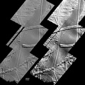
This image, acquired by NASA's Galileo spacecraft on September 26, 1998, shows features on the surface of Jupiter's moon Europa that a scientific report published today interprets as signs of compressive folding.


Information
- Taken in
- Author
- NASA/JPL/Johns Hopkins University Applied Physics Laboratory/Brown University
- Description
-
This image, acquired by NASA's Galileo spacecraft on September 26, 1998, shows features on the surface of Jupiter's moon Europa that a scientific report published today interprets as signs of compressive folding.
The imaged area is in the Astypalaea Linea region of Europa's southern hemisphere, seen with low-angle sunshine coming from the upper right. North is toward the top.
Astypalaea Linea is the smooth, gray area that stretches from north to south across the image mosaic. It is thought to have formed by a combination of pulling apart and sliding of the icy surface. The telltale fold features are within the smoother portions of the surface between the more dominant ridges, which are attributed to upwelling of material through surface ice. In the smooth areas, the surface has gentle swells and dips, which show most clearly in the version on the right, processed to accentuate broader-scale shapes. For example, a dip about 15 kilometers (about 10 miles) wide cuts diagonally across the northern half of the largest smooth area, and a rise runs parallel to that in the southern half of the smooth area.
- Created on
- Friday 11 August 2000
- Albums
- US SPACE PROGRAM / PROBES / JUPITER / GALILEO / Mission Photos (Edited) / JUPITER / EUROPA
- Source link
- https://photojournal.jpl.nasa.gov
- Visits
- 10
- Rating score
- no rate
- Rate this photo
- License
- Public Domain
- Modified by WikiArchives
- No (original)
- Downloads
- 1
Powered by Piwigo