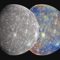
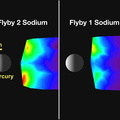
. MESSENGER has now seen about 80% of Mercury from two encounters this year (14 January and 6 October, middle and bottom maps respectively). The narrow regions outlined in blue are the sunlit crescents seen as MESSENGER approached Mercury during each flyby (Mercury flyby 1 approach crescent (see PIA10179); Mercury flyby 2 approach crescent) (see PIA11247). The larger areas outlined in orange are the sunlit portions of the surface seen as MESSENGER departed the Solar System’s innermost planet (Mercury flyby 1 departure view (see PIA10172); Mercury flyby 2 departure view (see PIA11245). The second flyby on October 6 filled in most of the areas that had never before been imaged by spacecraft. Between Mariner 10 and MESSENGER, we have now mapped about 90% of Mercury at a resolution of 1 kilometer or better. Because of the fast encounter velocity and Mercury’s slow rotation, the lighting angle within the global mosaic varies from high noon to just over the horizon, resulting in a non-uniform look at the planet. After MESSENGER enters orbit about Mercury in 2011, a higher-resolution (250 meters/pixel) global mosaic will be built up with more uniform illumination.
Date Acquired: January 14 and October 6, 2008
Instrument: Wide Angle Camera (WAC) of the Mercury Dual Imaging System (MDIS)
Scale: Mercury’s diameter is 4880 kilometers (3030 miles)")
WIKIARCHIVES.SPACE
The Human Spaceflight Archive
Shown here are three imagery coverage maps of Mercury. Mariner 10 photographed approximately 45% of Mercury’s surface during three flybys in the mid-1970s (top map). MESSENGER has now seen about 80% of Mercury from two encounters this year (14 January and 6 October, middle and bottom maps respectively). The narrow regions outlined in blue are the sunlit crescents seen as MESSENGER approached Mercury during each flyby (Mercury flyby 1 approach crescent (see PIA10179); Mercury flyby 2 approach crescent) (see PIA11247). The larger areas outlined in orange are the sunlit portions of the surface seen as MESSENGER departed the Solar System’s innermost planet (Mercury flyby 1 departure view (see PIA10172); Mercury flyby 2 departure view (see PIA11245). The second flyby on October 6 filled in most of the areas that had never before been imaged by spacecraft. Between Mariner 10 and MESSENGER, we have now mapped about 90% of Mercury at a resolution of 1 kilometer or better. Because of the fast encounter velocity and Mercury’s slow rotation, the lighting angle within the global mosaic varies from high noon to just over the horizon, resulting in a non-uniform look at the planet. After MESSENGER enters orbit about Mercury in 2011, a higher-resolution (250 meters/pixel) global mosaic will be built up with more uniform illumination.


Information
- Taken in
- Author
- NASA/Johns Hopkins University Applied Physics Laboratory/Carnegie Institution of Washington
- Description
-
Shown here are three imagery coverage maps of Mercury. Mariner 10 photographed approximately 45% of Mercury’s surface during three flybys in the mid-1970s (top map). MESSENGER has now seen about 80% of Mercury from two encounters this year (14 January and 6 October, middle and bottom maps respectively). The narrow regions outlined in blue are the sunlit crescents seen as MESSENGER approached Mercury during each flyby (Mercury flyby 1 approach crescent (see PIA10179); Mercury flyby 2 approach crescent) (see PIA11247). The larger areas outlined in orange are the sunlit portions of the surface seen as MESSENGER departed the Solar System’s innermost planet (Mercury flyby 1 departure view (see PIA10172); Mercury flyby 2 departure view (see PIA11245). The second flyby on October 6 filled in most of the areas that had never before been imaged by spacecraft. Between Mariner 10 and MESSENGER, we have now mapped about 90% of Mercury at a resolution of 1 kilometer or better. Because of the fast encounter velocity and Mercury’s slow rotation, the lighting angle within the global mosaic varies from high noon to just over the horizon, resulting in a non-uniform look at the planet. After MESSENGER enters orbit about Mercury in 2011, a higher-resolution (250 meters/pixel) global mosaic will be built up with more uniform illumination.
Date Acquired: January 14 and October 6, 2008
Instrument: Wide Angle Camera (WAC) of the Mercury Dual Imaging System (MDIS)
Scale: Mercury’s diameter is 4880 kilometers (3030 miles)
- Created on
- Wednesday 29 October 2008
- Albums
- US SPACE PROGRAM / PROBES / MERCURY / MESSENGER / Annoted/Science
- Source link
- https://photojournal.jpl.nasa.gov
- Visits
- 25
- Rating score
- no rate
- Rate this photo
- License
- Public Domain
- Modified by WikiArchives
- No (original)
- Downloads
- 0
Powered by Piwigo