 of the Mercury Dual Imaging System (MDIS)")
WIKIARCHIVES.SPACE
The Human Spaceflight Archive
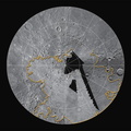
The top image shows an example of the limitations of flyby imaging. Although image coverage of Mercury from the MESSENGER and Mariner 10 flybys extended to approximately 98% of the surface, such images were obtained at varying resolution and lighting and often at extreme viewing geometries. This scene at 74° N, 336° E, shows a region viewed during MESSENGER's second flyby, but its high-latitude location made the recognition of surface features a difficult task. The scene is approximately 275 km from top to bottom.


Information
- Taken in
- Author
- NASA/Johns Hopkins University Applied Physics Laboratory/Carnegie Institution of Washington
- Description
-
The top image shows an example of the limitations of flyby imaging. Although image coverage of Mercury from the MESSENGER and Mariner 10 flybys extended to approximately 98% of the surface, such images were obtained at varying resolution and lighting and often at extreme viewing geometries. This scene at 74° N, 336° E, shows a region viewed during MESSENGER's second flyby, but its high-latitude location made the recognition of surface features a difficult task. The scene is approximately 275 km from top to bottom.
The bottom image shows the same terrain and the advantages of a global perspective. MESSENGER's orbital images have been overlaid on the top image. Even for previously imaged portions of the surface, orbital observations reveal a new level of detail. This region is part of the extensive northern plains, and evidence for a volcanic origin can now be seen. Several examples of "ghost" craters, preexisting craters that were buried by the emplacement of the plains, are seen near the center of the mosaic.
The MESSENGER spacecraft is the first ever to orbit the planet Mercury, and the spacecraft's seven scientific instruments and radio science investigation are unraveling the history and evolution of the Solar System's innermost planet. Visit the Why Mercury? section of this website to learn more about the key science questions that the MESSENGER mission is addressing.
Date Presented: June 16, 2011, at a NASA press conference
Instrument: Wide Angle Camera (WAC) of the Mercury Dual Imaging System (MDIS)
- Created on
- Thursday 16 June 2011
- Albums
- US SPACE PROGRAM / PROBES / MERCURY / MESSENGER / Annoted/Science
- Source link
- https://photojournal.jpl.nasa.gov
- Visits
- 15
- Rating score
- no rate
- Rate this photo
- License
- Public Domain
- Modified by WikiArchives
- No (original)
- Downloads
- 2
Powered by Piwigo