. A tectonic survey of the Caloris basin, Mercury. 43rd Lunar and Planetary Science Conference, The Woodlands, Texas, abstract #1722.
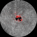
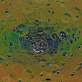
Center Latitude: 31°
Center Longitude: 163° E
Scale: Caloris basin has a diameter of 1,550 kilometers (960 miles)
Reference: From abstract #1722 by Paul K. Byrne and coauthors at the 43rd Lunar and Planetary Science Conference
The MESSENGER spacecraft is the first ever to orbit the planet Mercury, and the spacecraft's seven scientific instruments and radio science investigation are unraveling the history and evolution of the Solar System's innermost planet. Visit the Why Mercury? section of this website to learn more about the key science questions that the MESSENGER mission is addressing. During the one-year primary mission, MDIS acquired 88,746 images and extensive other data sets. MESSENGER is now in a year-long extended mission, during which plans call for the acquisition of more than 80,000 additional images to support MESSENGER's science goals.")
WIKIARCHIVES.SPACE
The Human Spaceflight Archive
The large Caloris basin hosts a wide variety of tectonic features, including graben, ridges, and Pantheon Fossae. MESSENGER team members are in the process of mapping the tectonic features within the Caloris basin and deciphering their complicated relationships. The tectonic map shown here was published in the abstracts of the 43rd Lunar and Planetary Science Conference, which is being held this week in The Woodlands, Texas. In total, MESSENGER team members are presenting 57 papers at this conference.


Information
- Taken in
- Author
- NASA/Johns Hopkins University Applied Physics Laboratory/Carnegie Institution of Washington/Byrne et al.
- Description
-
The large Caloris basin hosts a wide variety of tectonic features, including graben, ridges, and Pantheon Fossae. MESSENGER team members are in the process of mapping the tectonic features within the Caloris basin and deciphering their complicated relationships. The tectonic map shown here was published in the abstracts of the 43rd Lunar and Planetary Science Conference, which is being held this week in The Woodlands, Texas. In total, MESSENGER team members are presenting 57 papers at this conference.
Credit: Byrne et al. (2012). A tectonic survey of the Caloris basin, Mercury. 43rd Lunar and Planetary Science Conference, The Woodlands, Texas, abstract #1722.
Center Latitude: 31°
Center Longitude: 163° E
Scale: Caloris basin has a diameter of 1,550 kilometers (960 miles)
Reference: From abstract #1722 by Paul K. Byrne and coauthors at the 43rd Lunar and Planetary Science Conference
The MESSENGER spacecraft is the first ever to orbit the planet Mercury, and the spacecraft's seven scientific instruments and radio science investigation are unraveling the history and evolution of the Solar System's innermost planet. Visit the Why Mercury? section of this website to learn more about the key science questions that the MESSENGER mission is addressing. During the one-year primary mission, MDIS acquired 88,746 images and extensive other data sets. MESSENGER is now in a year-long extended mission, during which plans call for the acquisition of more than 80,000 additional images to support MESSENGER's science goals.
- Created on
- Tuesday 20 March 2012
- Albums
- US SPACE PROGRAM / PROBES / MERCURY / MESSENGER / Annoted/Science
- Source link
- https://photojournal.jpl.nasa.gov
- Visits
- 13
- Rating score
- no rate
- Rate this photo
- License
- Public Domain
- Modified by WikiArchives
- No (original)
- Downloads
- 0
Powered by Piwigo