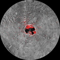
 is shown in white on MESSENGER orbital images colorized by the faction of time the surface is illuminated. Areas in permanent shadow are black on the illumination map. Radar-bright features in the Arecibo image all collocate with areas mapped as in permanent shadow, consistent with the proposal that radar-bright materials contain water ice. This image is shown in a polar stereographic projection with every 5° of latitude and 30° of longitude indicated and with 0° longitude at the top. The large crater near Mercury's south pole, Chao Meng-Fu, has a diameter of 180 km.
Instrument: Wide Angle Camera (WAC) of the Mercury Dual Imaging System (MDIS)
The MESSENGER spacecraft is the first ever to orbit the planet Mercury, and the spacecraft's seven scientific instruments and radio science investigation are unraveling the history and evolution of the Solar System's innermost planet. Visit the Why Mercury? section of this website to learn more about the key science questions that the MESSENGER mission is addressing. During the one-year primary mission, MDIS acquired 88,746 images and extensive other data sets. MESSENGER is now in a year-long extended mission, during which plans call for the acquisition of more than 80,000 additional images to support MESSENGER's science goals.")
WIKIARCHIVES.SPACE
The Human Spaceflight Archive
The highest-resolution radar image of Mercury's south polar region made from the Arecibo Observatory (Harmon et al., Icarus, 211, 37-50, 2011) is shown in white on MESSENGER orbital images colorized by the faction of time the surface is illuminated. Areas in permanent shadow are black on the illumination map. Radar-bright features in the Arecibo image all collocate with areas mapped as in permanent shadow, consistent with the proposal that radar-bright materials contain water ice. This image is shown in a polar stereographic projection with every 5° of latitude and 30° of longitude indicated and with 0° longitude at the top. The large crater near Mercury's south pole, Chao Meng-Fu, has a diameter of 180 km.


Information
- Taken in
- Author
- NASA/Johns Hopkins University Applied Physics Laboratory/Carnegie Institution of Washington
- Description
-
The highest-resolution radar image of Mercury's south polar region made from the Arecibo Observatory (Harmon et al., Icarus, 211, 37-50, 2011) is shown in white on MESSENGER orbital images colorized by the faction of time the surface is illuminated. Areas in permanent shadow are black on the illumination map. Radar-bright features in the Arecibo image all collocate with areas mapped as in permanent shadow, consistent with the proposal that radar-bright materials contain water ice. This image is shown in a polar stereographic projection with every 5° of latitude and 30° of longitude indicated and with 0° longitude at the top. The large crater near Mercury's south pole, Chao Meng-Fu, has a diameter of 180 km.
Instrument: Wide Angle Camera (WAC) of the Mercury Dual Imaging System (MDIS)
The MESSENGER spacecraft is the first ever to orbit the planet Mercury, and the spacecraft's seven scientific instruments and radio science investigation are unraveling the history and evolution of the Solar System's innermost planet. Visit the Why Mercury? section of this website to learn more about the key science questions that the MESSENGER mission is addressing. During the one-year primary mission, MDIS acquired 88,746 images and extensive other data sets. MESSENGER is now in a year-long extended mission, during which plans call for the acquisition of more than 80,000 additional images to support MESSENGER's science goals.
- Created on
- Wednesday 21 March 2012
- Albums
- US SPACE PROGRAM / PROBES / MERCURY / MESSENGER / Annoted/Science
- Source link
- https://photojournal.jpl.nasa.gov
- Visits
- 16
- Rating score
- no rate
- Rate this photo
- License
- Public Domain
- Modified by WikiArchives
- No (original)
- Downloads
- 1
Powered by Piwigo