 of the Mercury Dual Imaging System (MDIS) and Visible and Infrared Spectrograph (VIRS) of the Mercury Atmosphere and Surface Composition Spectrometer (MASCS)
Center Latitude: 38°
Center Longitude: 85.5° E
Map Projection: Simple Cylindrical
MDIS WAC filters: 9, 7, 6 (996, 748, 433 nanometers) in red, green, and blue
VIRS Color Composite Wavelengths: 575 nm as red, 415 nm/750 nm as green, 310 nm/390 nm as blue
Scale: Caloris Basin is 1,550 km (963 mi) across.")
WIKIARCHIVES.SPACE
The Human Spaceflight Archive
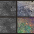
Today's image features four views of the northeastern hemisphere of Mercury. In each panel, the bottom left corner is 0°N,0°E and the top right corner is 76°N,171°E. Most of Caloris basin can be seen along the right edge of each panel. The top left panel is a monochromatic image of the region as viewed by the wide angle camera on MDIS. Unlike MDIS, which takes images in much the same way a digital camera does, the MASCS instrument captures many wavelengths of light from a single spot on the surface at a time, creating a spectral profile of the surface as MESSENGER orbits Mercury. The MASCS/VIRS instrument has accumulated enough of these profiles that the reflectance of the surface can be interpolated to reveal the same surface details seen in the MDIS basemap. This interpolated map is shown in the bottom left panel of today's image.
Information
- Taken in
- Author
- NASA/Johns Hopkins University Applied Physics Laboratory/Carnegie Institution of Washington
- Description
-
Today's image features four views of the northeastern hemisphere of Mercury. In each panel, the bottom left corner is 0°N,0°E and the top right corner is 76°N,171°E. Most of Caloris basin can be seen along the right edge of each panel. The top left panel is a monochromatic image of the region as viewed by the wide angle camera on MDIS. Unlike MDIS, which takes images in much the same way a digital camera does, the MASCS instrument captures many wavelengths of light from a single spot on the surface at a time, creating a spectral profile of the surface as MESSENGER orbits Mercury. The MASCS/VIRS instrument has accumulated enough of these profiles that the reflectance of the surface can be interpolated to reveal the same surface details seen in the MDIS basemap. This interpolated map is shown in the bottom left panel of today's image.
Both of these instruments probe the spectral 'fingerprint' of rocks on Mercury's surface in different ways, enabling scientists to map the compositional variations of the rocks on the surface by observing how light interacts with them. The top right image presents the color diversity observed by MDIS by filtering the light that is reflected by Mercury at discrete visible and infrared wavelengths, and the bottom right presents the spectral diversity observed by MASCS/VIRS by mapping several parameters that combine visible and ultraviolet wavelengths. Though surface features show diversity in MDIS color, there are further variations in the spectral signature when ultraviolet light measured by MASCS/VIRS is visualized.
Instruments: Wide Angle Camera (WAC) of the Mercury Dual Imaging System (MDIS) and Visible and Infrared Spectrograph (VIRS) of the Mercury Atmosphere and Surface Composition Spectrometer (MASCS)
Center Latitude: 38°
Center Longitude: 85.5° E
Map Projection: Simple Cylindrical
MDIS WAC filters: 9, 7, 6 (996, 748, 433 nanometers) in red, green, and blue
VIRS Color Composite Wavelengths: 575 nm as red, 415 nm/750 nm as green, 310 nm/390 nm as blue
Scale: Caloris Basin is 1,550 km (963 mi) across.
- Created on
- Tuesday 4 June 2013
- Albums
- US SPACE PROGRAM / PROBES / MERCURY / MESSENGER / Annoted/Science
- Source link
- https://photojournal.jpl.nasa.gov
- Visits
- 18
- Rating score
- no rate
- Rate this photo
- License
- Public Domain
- Modified by WikiArchives
- No (original)
- Downloads
- 0
Powered by Piwigo