 elevation model.
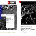
You can access QuickMap here. Follow the four steps given below and numbered in the above diagram to create your own 3D view of Mercury's surface!
Step 1: Use the box tool at the top right. Click, hold, and drag the box.
Step 2: Click on the box, chose query , and select 3D Live View.
Step 3: Follow the link labeled here to access the 3D tool.
Step 4: Adjust the settings to create a 3D view and use autorotate to produce a movie.
Elevation Model: Goddard (PDS9)
Center Latitude: 85°
Center Longitude: 150° E
Scale: About 87 km (54 mi) box width
Instruments: Mercury Dual Imaging System (MDIS) and Mercury Laser Altimeter (MLA)")
WIKIARCHIVES.SPACE
The Human Spaceflight Archive
The ACT-REACT Quickmap tool, which is available on the left-side tab, has recently been updated. Check out the cool new 3D Live View function to visualize Mercury's surface! The 3D view is made using the MLA Goddard (PDS9) elevation model.


Information
- Taken in
- Author
- NASA/Johns Hopkins University Applied Physics Laboratory/Carnegie Institution of Washington
- Description
-
The ACT-REACT Quickmap tool, which is available on the left-side tab, has recently been updated. Check out the cool new 3D Live View function to visualize Mercury's surface! The 3D view is made using the MLA Goddard (PDS9) elevation model.
You can access QuickMap here. Follow the four steps given below and numbered in the above diagram to create your own 3D view of Mercury's surface!
Step 1: Use the box tool at the top right. Click, hold, and drag the box.
Step 2: Click on the box, chose "query", and select "3D Live View."
Step 3: Follow the link labeled "here" to access the 3D tool.
Step 4: Adjust the settings to create a 3D view and use autorotate to produce a movie.
Elevation Model: Goddard (PDS9)
Center Latitude: 85°
Center Longitude: 150° E
Scale: About 87 km (54 mi) box width
Instruments: Mercury Dual Imaging System (MDIS) and Mercury Laser Altimeter (MLA)
- Created on
- Thursday 11 July 2013
- Albums
- US SPACE PROGRAM / PROBES / MERCURY / MESSENGER / Annoted/Science
- Source link
- https://photojournal.jpl.nasa.gov
- Visits
- 16
- Rating score
- no rate
- Rate this photo
- License
- Public Domain
- Modified by WikiArchives
- No (original)
- Downloads
- 0
Powered by Piwigo