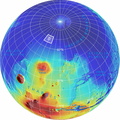
 from the top of the highest volcano (red) to the northern lowlands (blue). North pole is where the longitude lines converge.
Photojournal Note: As planned, the Phoenix lander, which landed May 25, 2008 23:53 UTC, ended communications in November 2008, about six months after landing, when its solar panels ceased operating in the dark Martian winter.")
WIKIARCHIVES.SPACE
The Human Spaceflight Archive
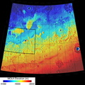
The planned landing site for NASA's Phoenix Mars Lander lies at a latitude on Mars equivalent to northern Alaska on Earth. It is within the region designated "D" on this global image.


Information
- Taken in
- Autor
- NASA/JPL-Caltech/Washington Univ. St. Louis/Univ. of Arizona
- Beschreibung
-
The planned landing site for NASA's Phoenix Mars Lander lies at a latitude on Mars equivalent to northern Alaska on Earth. It is within the region designated "D" on this global image.
This is an orthographic projection with color-coded elevation contours and shaded relief based on data from the Mars Orbiter Laser Altimeter on NASA's Mars Global Surveyor orbiter. Total vertical relief is about 28 kilometers (17 miles) from the top of the highest volcano (red) to the northern lowlands (blue). North pole is where the longitude lines converge.
Photojournal Note: As planned, the Phoenix lander, which landed May 25, 2008 23:53 UTC, ended communications in November 2008, about six months after landing, when its solar panels ceased operating in the dark Martian winter.
- Erstellt am
- Donnerstag 2 August 2007
- Alben
- US SPACE PROGRAM / PROBES / MARS / PHOENIX / Annoted/Science
- Source link
- https://photojournal.jpl.nasa.gov
- Besuche
- 49
- Bewertung
- noch keine Bewertung
- Foto bewerten
- License
- Public Domain
- Modified by WikiArchives
- No (original)
- Downloads
- 0
Powered by Piwigo