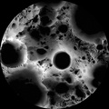
 is in the center, the south pole is located approximately at 9 o'clock on its rim. Mapped area extends from 88°S to 90°S.
The spin axis of the Moon is tilted by only 1.54° (compared to Earth's 23.5°), leaving some areas near the poles in permanent shadow while other nearby regions remain sunlit for the majority of the year. One of the primary objectives of LROC is to unambiguously identify these regions.
In a six month (six lunar days) period, the LROC Wide Angle Camera (WAC) collected 1,700 images of the South Pole covering the same area. Each image was map projected and converted to a binary image (if the ground was illuminated that pixel was set to one, and if shadowed zero) to differentiate between sunlit and shadowed regions. All the binary images were then stacked, and then for each pixel it was determined what percentage of the time during six months that spot was illuminated. Presto -- an illumination map! The LROC team is making daily (which is about 28 Earth days) and yearly illumination maps for both poles. Such maps will provide the foundation for planning future robotic and human missions to the poles.
NASA's Goddard Space Flight Center built and manages the mission for the Exploration Systems Mission Directorate at NASA Headquarters in Washington. The Lunar Reconnaissance Orbiter Camera was designed to acquire data for landing site certification and to conduct polar illumination studies and global mapping. Operated by Arizona State University, LROC consists of a pair of narrow-angle cameras (NAC) and a single wide-angle camera (WAC). The mission is expected to return over 70 terabytes of image data.")
WIKIARCHIVES.SPACE
The Human Spaceflight Archive
Multi-temporal illumination map of the lunar south pole, Shackleton crater (19 kilometers diameter, or 12 miles) is in the center, the south pole is located approximately at 9 o'clock on its rim. Mapped area extends from 88°S to 90°S.


Information
- Taken in
- Forfatter
- NASA/GSFC/Arizona State University
- Beskrivelse
-
Multi-temporal illumination map of the lunar south pole, Shackleton crater (19 kilometers diameter, or 12 miles) is in the center, the south pole is located approximately at 9 o'clock on its rim. Mapped area extends from 88°S to 90°S.
The spin axis of the Moon is tilted by only 1.54° (compared to Earth's 23.5°), leaving some areas near the poles in permanent shadow while other nearby regions remain sunlit for the majority of the year. One of the primary objectives of LROC is to unambiguously identify these regions.
In a six month (six lunar days) period, the LROC Wide Angle Camera (WAC) collected 1,700 images of the South Pole covering the same area. Each image was map projected and converted to a binary image (if the ground was illuminated that pixel was set to one, and if shadowed zero) to differentiate between sunlit and shadowed regions. All the binary images were then stacked, and then for each pixel it was determined what percentage of the time during six months that spot was illuminated. Presto -- an illumination map! The LROC team is making daily (which is about 28 Earth days) and yearly illumination maps for both poles. Such maps will provide the foundation for planning future robotic and human missions to the poles.
NASA's Goddard Space Flight Center built and manages the mission for the Exploration Systems Mission Directorate at NASA Headquarters in Washington. The Lunar Reconnaissance Orbiter Camera was designed to acquire data for landing site certification and to conduct polar illumination studies and global mapping. Operated by Arizona State University, LROC consists of a pair of narrow-angle cameras (NAC) and a single wide-angle camera (WAC). The mission is expected to return over 70 terabytes of image data.
- Opprettet den
- Onsdag 15 Desember 2010
- Albumer
- US SPACE PROGRAM / PROBES / MOON / LRO/LCROSS / Mission Photos (Edited)
- Source link
- https://photojournal.jpl.nasa.gov
- Besøk
- 18
- Vurdering poengsum
- ingen vurdering
- Vurder dette bildet
- License
- Public Domain
- Modified by WikiArchives
- No (original)
- Nedlastinger
- 1
Drevet av Piwigo