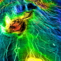
 of the larger surrounding tesserae. The larger, lower island in the foreground has a much higher emissivity (shown in red), either because it lies at a slightly lower elevation or because of its age and origin. It appears to be a corona PIA00307. To the east of the region shown, the rift system forms a chain of moats linking numerous large and prominent coronae. Magellan MIDR quadrangle* containing this image: C1-15S129. Image resolution (m): 225. Size of region shown (E-W x N-S, in km): 1125 x 1125. Range of emissivities from violet to red: 0.50 - - 0.89. Vertical exaggeration: 20. Azimuth of viewpoint (deg clockwise from East): 150. Elevation of viewpoint (km): 1200. *Quadrangle name indicates approximate center latitude (N=north, S=south) and center longitude (East).")
WIKIARCHIVES.SPACE
The Human Spaceflight Archive


Information
- Taken in
- 作者
- NASA/JPL/USGS
- 描述
- This perspective view of Venus, generated by computer from Magellan data and color-coded with emissivity, shows the boundary between the lowland plains and characteristic Venusian highland terrain in Ovda Regio, the western part of the great equatorial highland called Aphrodite Terra. For a view of the simpler lowland-highland boundary to the north, see PIA00310. The view is oblique to the southern boundary of Ovda. Whereas the lowlands to the right are made up of overlapping, relatively dark and smooth lava flows decorated with a system of parallel fractures, the highlands consist mainly of "tessera terrain" with a complex pattern of intersecting sets of subparallel fractures and ridges. Notable here is the deep rift valley that transects the highlands in the center of the image. Such canyons are common where Venus' global network of tectonic belts traverses the highlands. A small "island" of tessera terrain in the background shares the low emissivity (indicated by the blue color) of the larger surrounding tesserae. The larger, lower "island" in the foreground has a much higher emissivity (shown in red), either because it lies at a slightly lower elevation or because of its age and origin. It appears to be a corona PIA00307. To the east of the region shown, the rift system forms a chain of moats linking numerous large and prominent coronae. Magellan MIDR quadrangle* containing this image: C1-15S129. Image resolution (m): 225. Size of region shown (E-W x N-S, in km): 1125 x 1125. Range of emissivities from violet to red: 0.50 - - 0.89. Vertical exaggeration: 20. Azimuth of viewpoint (deg clockwise from East): 150. Elevation of viewpoint (km): 1200. *Quadrangle name indicates approximate center latitude (N=north, S=south) and center longitude (East).
- 创建于
- 星期四 4 六月 1998
- 相册
- US SPACE PROGRAM / PROBES / VENUS / MAGELLAN / Annoted/Science
- Source link
- https://photojournal.jpl.nasa.gov
- 访问量
- 20
- 评价得分
- 没有评分
- 评分
- License
- Public Domain
- Modified by WikiArchives
- No (original)
- 下载
- 0
技术支持 Piwigo