 by 110 kilometers (68 miles) covers part of the eastern flank of the volcano Sapas Mons on the western edge of Atla Regio. The bright lobate features along the southern and the western part of the image, oriented in northeast to southwest directions, are lava flows that are rough at the 12.6 centimeter wavelength of the radar. These flows range in width from 5 kilometers to 25 kilometers (3 to 16 miles) with lengths of 50 kilometers to 100 kilometers (31 to 62 miles), extending off the area shown here. Additional radar-dark (smooth) flows are also present. The radar-bright linear structures in the northwest part of the image are interpreted to be faults and fractures possibly associated with the emplacement of magma in the subsurface. Located near the center of the image is a 20 kilometer (12 mile) diameter impact crater. This crater is superimposed on a northeast/southwest trending fracture while the southern part of the crater's ejecta blanket is covered by a 6 kilometer (4 mile) wide radar-bright lava flow. These relations indicate that the crater post dates an episode of fracturing and is older than the lava flows covering its southern edge. This is one of only a few places on Venus in which an impact crater is seen to be covered by volcanic deposits.")
WIKIARCHIVES.SPACE
The Human Spaceflight Archive


Information
- Taken in
- Author
- NASA/JPL-Caltech
- Description
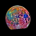
- This Magellan image centered near 9.6 degrees north latitude, 189.5 degrees east longitude of an area 140 kilometers (87 miles) by 110 kilometers (68 miles) covers part of the eastern flank of the volcano Sapas Mons on the western edge of Atla Regio. The bright lobate features along the southern and the western part of the image, oriented in northeast to southwest directions, are lava flows that are rough at the 12.6 centimeter wavelength of the radar. These flows range in width from 5 kilometers to 25 kilometers (3 to 16 miles) with lengths of 50 kilometers to 100 kilometers (31 to 62 miles), extending off the area shown here. Additional radar-dark (smooth) flows are also present. The radar-bright linear structures in the northwest part of the image are interpreted to be faults and fractures possibly associated with the emplacement of magma in the subsurface. Located near the center of the image is a 20 kilometer (12 mile) diameter impact crater. This crater is superimposed on a northeast/southwest trending fracture while the southern part of the crater's ejecta blanket is covered by a 6 kilometer (4 mile) wide radar-bright lava flow. These relations indicate that the crater post dates an episode of fracturing and is older than the lava flows covering its southern edge. This is one of only a few places on Venus in which an impact crater is seen to be covered by volcanic deposits.
- Created on
- Monday 29 January 1996
- Albums
- US SPACE PROGRAM / PROBES / VENUS / MAGELLAN / Mission Photos (Edited)
- Source link
- https://photojournal.jpl.nasa.gov
- Visits
- 19
- Rating score
- no rate
- Rate this photo
- License
- Public Domain
- Modified by WikiArchives
- No (original)
- Downloads
- 3
Powered by Piwigo