, Edwards, California, in a joint NASA-Defense Advanced Research Projects Agency-Air Force program to investigate the unique design's high-angle-of-attack characteristics and its military utility. Tufts -- small strips of cloth attached to the surface of the aircraft to visually study the flow of air over the aircraft -- can be seen on the aft fuselage, wing, and tail surfaces of the X-29 in this photo. Angle of attack, or high alpha, refers to the angle of an aircraft's body and wings relative to its actual flight path. This aircraft was flown at Dryden from May 1989 until August 1992.")
WIKIARCHIVES.SPACE
The Human Spaceflight Archive


Information
- Taken in
- Edwards Air Force Base
- Author
- NASA
- Description
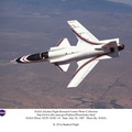
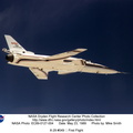
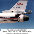
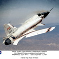
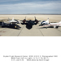
- The No. 2 X-29 technology demonstrator aircraft is seen here during a 1990 test flight. At this angle, the aircraft’s unique forward-swept wing design is clearly visible. The X-29 was flown by NASA's Ames-Dryden Flight Research Facility (later redesignated the Dryden Flight Research Center), Edwards, California, in a joint NASA-Defense Advanced Research Projects Agency-Air Force program to investigate the unique design's high-angle-of-attack characteristics and its military utility. Tufts -- small strips of cloth attached to the surface of the aircraft to visually study the flow of air over the aircraft -- can be seen on the aft fuselage, wing, and tail surfaces of the X-29 in this photo. Angle of attack, or high alpha, refers to the angle of an aircraft's body and wings relative to its actual flight path. This aircraft was flown at Dryden from May 1989 until August 1992.
- Created on
- Albums
- US SPACE PROGRAM / AERONAUTICS RESEARCH / X-29
- Source link
- https://www.dfrc.nasa.gov/Gallery/index.html
- Visits
- 7
Location : 34.954046, -117.873320
- Rating score
- no rate
- Rate this photo
- License
- Public Domain
- Modified by WikiArchives
- No (original)
- Downloads
- 0
Powered by Piwigo