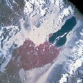
 when this picture was made the Apollo 9 spacecraft was at an altitude of 103 nautical miles, and the sun elevation was 45 degrees above at which the four-camera combination was aimed was 33 degrees 3 minutes north latitude, and 115 degrees 45 minutes west longitude. The other three cameras used: (B) black and white film with a red filter; (C) black and white infrared film; and (D) black and white film with a green filter.")
WIKIARCHIVES.SPACE
The Human Spaceflight Archive


Information
- Taken in
- Space
- Author
- NASA
- Description
- A color infrared photograph of the Salton Sea and Imperial Valley area of Southern California and the Mexicali, Mexico area, taken on March 9, 1969, by one of the four synchronized cameras of the Apollo 9 Earth Resources Survey S065 Experiment. At 2:36 p.m. (EST) when this picture was made the Apollo 9 spacecraft was at an altitude of 103 nautical miles, and the sun elevation was 45 degrees above at which the four-camera combination was aimed was 33 degrees 3 minutes north latitude, and 115 degrees 45 minutes west longitude. The other three cameras used: (B) black and white film with a red filter; (C) black and white infrared film; and (D) black and white film with a green filter.
- Created on
- Sunday 9 March 1969
- Albums
- US SPACE PROGRAM / APOLLO / APOLLO 9 / Mission Photos (Edited)
- Source link
- https://www.flickr.com/photos/nasa2explore/9349154221/in/album-72157634765433538/
- Visits
- 128
- Rating score
- no rate
- Rate this photo
- License
- Public Domain
- Modified by WikiArchives
- No (original)
- Downloads
- 1
Powered by Piwigo