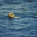
 in diameter, and it is centered near 91.5 degrees west longitude and 44.5 degrees north latitude. The Mississippi River Valley forms the southwest side of the circular feature. The City of La Crosse, Wisconsin, is just south of the near side of the circle, and the Black River completes the southern and eastern part. The City of Eau Claire is at the north edge of the circle. The most likely origin of circular features of this magnitude are (1) volcanic, (2) structural, or (3) meteorite impact. The feature is not volcanic -- the rocks are the wrong type. Possibly it is structural, formed by slight warping of layered rocks into a basin or dome, followed by erosion of all but the most subtle trace of the structure. The feature could be a severely eroded meteorite impact crater. If so, a thorough study of the area may yield evidence of the extreme pressure and temperature the rocks were subjected to by the shock of an impacting meteorite.")
WIKIARCHIVES.SPACE
The Human Spaceflight Archive


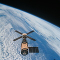
Information
- Taken in
- Space
- Author
- NASA
- Description
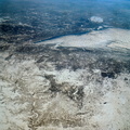
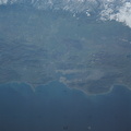
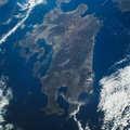
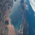
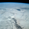
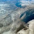
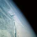
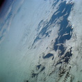
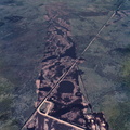
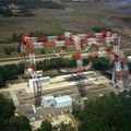
- An oblique view of a portion of the Middle West looking northeastward toward Lake Superior and Ontario, Canada, as seen from the Skylab space station in Earth orbit. This picture was taken by one of the Skylab 4 crewmen with a hand-held 70mm Hasselblad camera using a 100mm lens. Most of the land mass in the foreground is Wisconsin. Iowa is in the lower left corner. Minnesota is at left and upper left. Ontario is in the far right background. Michigan is at right center. Note the circular-shaped feature at center left which was first observed by the Skylab 4 crewmen. The feature is 85 kilometers (55 miles) in diameter, and it is centered near 91.5 degrees west longitude and 44.5 degrees north latitude. The Mississippi River Valley forms the southwest side of the circular feature. The City of La Crosse, Wisconsin, is just south of the near side of the circle, and the Black River completes the southern and eastern part. The City of Eau Claire is at the north edge of the circle. The most likely origin of circular features of this magnitude are (1) volcanic, (2) structural, or (3) meteorite impact. The feature is not volcanic -- the rocks are the wrong type. Possibly it is structural, formed by slight warping of layered rocks into a basin or dome, followed by erosion of all but the most subtle trace of the structure. The feature could be a severely eroded meteorite impact crater. If so, a thorough study of the area may yield evidence of the extreme pressure and temperature the rocks were subjected to by the shock of an impacting meteorite.
- Created on
- સોમવાર 7 જાન્યુઆરી 1974
- Albums
- US SPACE PROGRAM / SKYLAB / SKYLAB 4 / Mission Photos (Original)
- Source link
- https://www.flickr.com/photos/nasa2explore/albums/72157638838227374
- Visits
- 78
- Rating score
- no rate
- Rate this photo
- License
- CC BY-NC
- Modified by WikiArchives
- No (original)
- Downloads
- 0
Powered by Piwigo