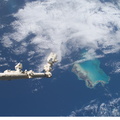
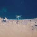
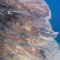
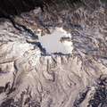
. This oblique, south-looking view shows the dramatic canyons of Peru’s southern coast (15.5 – 17 degrees S). According to NASA scientists studying ISS imagery, these are relatively young features carved by rivers mainly over the past 8 million years following the last major upheaval of the Andes Mountains. The canyons are some of the steepest and deepest on Earth—lake Laguna Parincocha (top left corner) lies on the Andean plateau about 3,250 meters above sea level, only 80 kilometers from the coast. A sheet of volcanic rock (known as an ignimbrite deposit) emplaced during an explosive eruptive event is scored with a dense pattern of parallel dry streams in the lower left corner of the image. Volcanic source regions for the ignimbrite lie outside the left margin of the view. The Yauca and Acarí rivers feed small tan-colored sediment plumes into the sea (lower right). Dark green agricultural fields cluster along the lower courses of the rivers. Strong southerly winds have generated sand dunes and dark wind streaks along the coast, whose alignments re-curve inland into the lower river valleys (lower right). The coast and canyons are commonly hazy due to oceanic air and blowing dust. Yellow lines parallel with the coast and near the small peninsula, according to scientists, are raised shorelines probably caused by tectonic uplift of the coastline")
WIKIARCHIVES.SPACE
The Human Spaceflight Archive


Information
- Taken in
- Space
- Author
- NASA
- Description
- The Arid Coast of Peru is featured in this digital image photographed by an Expedition 6 crewmember on the International Space Station (ISS). This oblique, south-looking view shows the dramatic canyons of Peru’s southern coast (15.5 – 17 degrees S). According to NASA scientists studying ISS imagery, these are relatively young features carved by rivers mainly over the past 8 million years following the last major upheaval of the Andes Mountains. The canyons are some of the steepest and deepest on Earth—lake Laguna Parincocha (top left corner) lies on the Andean plateau about 3,250 meters above sea level, only 80 kilometers from the coast. A sheet of volcanic rock (known as an ignimbrite deposit) emplaced during an explosive eruptive event is scored with a dense pattern of parallel dry streams in the lower left corner of the image. Volcanic source regions for the ignimbrite lie outside the left margin of the view. The Yauca and Acarí rivers feed small tan-colored sediment plumes into the sea (lower right). Dark green agricultural fields cluster along the lower courses of the rivers. Strong southerly winds have generated sand dunes and dark wind streaks along the coast, whose alignments re-curve inland into the lower river valleys (lower right). The coast and canyons are commonly hazy due to oceanic air and blowing dust. Yellow lines parallel with the coast and near the small peninsula, according to scientists, are raised shorelines probably caused by tectonic uplift of the coastline
- Created on
- Friday 14 March 2003
- Albums
- ISS (WIP) / EXPEDITIONS / EXPEDITION 06
- Source link
- https://www.flickr.com/photos/nasa2explore/albums/72157635065036373/
- Visits
- 378
- Rating score
- no rate
- Rate this photo
- License
- Public Domain
- Modified by WikiArchives
- No (original)
- Downloads
- 0
Powered by Piwigo