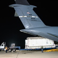
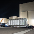
 satellite arrives from France aboard a U.S. Air Force C-5 Galaxy aircraft at Vandenberg Space Force Base in California, on Oct. 16, 2022. Teams will transport the satellite to Astrotech Space Operations facility to begin final preparations for the spacecraft’s December launch atop a SpaceX Falcon 9 rocket from Vandenberg’s Space Launch Center-4 East. Jointly developed by NASA and Centre National D'Etudes Spatiales, with contributions from the Canadian Space Agency (CSA) and United Kingdom Space Agency, SWOT is the first satellite mission that will observe nearly all water on Earth’s surface, measuring the height of water in the planet’s lakes, rivers, reservoirs, and the ocean")
WIKIARCHIVES.SPACE
The Human Spaceflight Archive


Information
- Taken in
- Vandenberg
- Author
- USSF 30th Space Wing/Carlos Vela
- Description
- NASA’s Surface Water and Ocean Topography (SWOT) satellite arrives from France aboard a U.S. Air Force C-5 Galaxy aircraft at Vandenberg Space Force Base in California, on Oct. 16, 2022. Teams will transport the satellite to Astrotech Space Operations facility to begin final preparations for the spacecraft’s December launch atop a SpaceX Falcon 9 rocket from Vandenberg’s Space Launch Center-4 East. Jointly developed by NASA and Centre National D'Etudes Spatiales, with contributions from the Canadian Space Agency (CSA) and United Kingdom Space Agency, SWOT is the first satellite mission that will observe nearly all water on Earth’s surface, measuring the height of water in the planet’s lakes, rivers, reservoirs, and the ocean
- Created on
- Monday 17 October 2022
- Albums
- FRENCH SPACE PROGRAM / SATELLITES / FALCON 9 / SWOT / Rocket preparation
- Source link
- https://images.nasa.gov
- Visits
- 48
- Rating score
- no rate
- Rate this photo
- License
- CC BY-NC-ND
- Modified by WikiArchives
- No (original)
- Downloads
- 0
EXIF Metadata
NIKON CORPORATION NIKON D810
- Make
- NIKON CORPORATION
- Model
- NIKON D810
- DateTimeOriginal
- 2022:10:17 02:48:25
- ApertureFNumber
- f/4.5
Powered by Piwigo