
WIKIARCHIVES.SPACE
The Human Spaceflight Archive


Information
- Taken in
- Space
- Author
- NASA
- Description
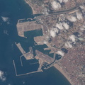
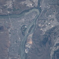
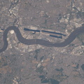
- The Canadian city of Winnipeg, Manitoba and the Assiniboine and Red Rivers are pictured as the International Space Station was orbiting at the northern-most point of its 51.7-degree orbital inclination.
- Created on
- Sunday 1 July 2018
- Albums
- ISS (WIP) / EXPEDITIONS / EXPEDITION 56
- Source link
- https://www.flickr.com/photos/nasa2explore/albums/72157681794432804
- Visits
- 14
- Rating score
- no rate
- Rate this photo
- License
- CC BY-NC-ND
- Modified by WikiArchives
- No (original)
- Downloads
- 1
EXIF Metadata
NIKON CORPORATION NIKON D5
- Make
- NIKON CORPORATION
- Model
- NIKON D5
- DateTimeOriginal
- 2018:07:01 14:54:01
- ApertureFNumber
- f/11.0
Powered by Piwigo