 cuts through the crater and distorts its originally circular shape. Though such deformation is more typical of Ganymede's bright grooved terrain, this image demonstrates that extreme tectonic disruption has occurred in the satellite's dark terrain also. The pair of oblong craters on the right was formed by the impact of a gravitationally bound pair of asteroids or a split comet. The oblong shapes of the craters suggest that the impactors struck the surface at a shallow angle. Toward the top left, an old crater has been partially buried by dark ejecta tossed from another impact about 50 kilometers to the north of this image.
North is to the top of the picture and the sun illuminates the surface from the right. The image, centered at 14 degrees south latitude and 352 degrees longitude, covers an area approximately 111 by 93 kilometers. The resolution is 180 meters per picture element. The image was taken on April 5, 1997 at 6 hours, 31 minutes, 44 seconds Universal Time at a range of 17,840 kilometers by the Solid State Imaging (SSI) system on NASA's Galileo spacecraft.
The Jet Propulsion Laboratory, Pasadena, CA manages the Galileo mission for NASA's Office of Space Science, Washington, DC.")
WIKIARCHIVES.SPACE
The Human Spaceflight Archive
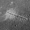
Dark terrain of Nicholson Regio on Jupiter's moon, Ganymede. On the left is a crater that has been torn apart by tectonic forces. A lane of ridges and grooves (probably extensional fault blocks) cuts through the crater and distorts its originally circular shape. Though such deformation is more typical of Ganymede's bright grooved terrain, this image demonstrates that extreme tectonic disruption has occurred in the satellite's dark terrain also. The pair of oblong craters on the right was formed by the impact of a gravitationally bound pair of asteroids or a split comet. The oblong shapes of the craters suggest that the impactors struck the surface at a shallow angle. Toward the top left, an old crater has been partially buried by dark ejecta tossed from another impact about 50 kilometers to the north of this image.


Information
- Taken in
- Author
- NASA/JPL/Brown University
- Description
-
Dark terrain of Nicholson Regio on Jupiter's moon, Ganymede. On the left is a crater that has been torn apart by tectonic forces. A lane of ridges and grooves (probably extensional fault blocks) cuts through the crater and distorts its originally circular shape. Though such deformation is more typical of Ganymede's bright grooved terrain, this image demonstrates that extreme tectonic disruption has occurred in the satellite's dark terrain also. The pair of oblong craters on the right was formed by the impact of a gravitationally bound pair of asteroids or a split comet. The oblong shapes of the craters suggest that the impactors struck the surface at a shallow angle. Toward the top left, an old crater has been partially buried by dark ejecta tossed from another impact about 50 kilometers to the north of this image.
North is to the top of the picture and the sun illuminates the surface from the right. The image, centered at 14 degrees south latitude and 352 degrees longitude, covers an area approximately 111 by 93 kilometers. The resolution is 180 meters per picture element. The image was taken on April 5, 1997 at 6 hours, 31 minutes, 44 seconds Universal Time at a range of 17,840 kilometers by the Solid State Imaging (SSI) system on NASA's Galileo spacecraft.
The Jet Propulsion Laboratory, Pasadena, CA manages the Galileo mission for NASA's Office of Space Science, Washington, DC.
- Created on
- Wednesday 15 July 1998
- Albums
- US SPACE PROGRAM / PROBES / JUPITER / GALILEO / Mission Photos (Edited) / JUPITER / GANYMEDE
- Source link
- https://photojournal.jpl.nasa.gov
- Visits
- 12
- Rating score
- no rate
- Rate this photo
- License
- Public Domain
- Modified by WikiArchives
- No (original)
- Downloads
- 3
Powered by Piwigo