 system on NASA's Galileo spacecraft.
The Jet Propulsion Laboratory, Pasadena, CA manages the Galileo mission for NASA's Office of Space Science, Washington, DC.")
WIKIARCHIVES.SPACE
The Human Spaceflight Archive
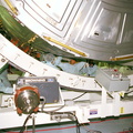
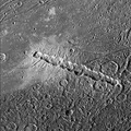
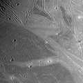
This image is a computer-generated perspective view of ridges in the Uruk Sulcus region of Jupiter's moon, Ganymede. This area is part of the bright grooved terrain that covers over half of Ganymede's surface, where the icy surface has been fractured and broken into many parallel ridges and troughs. Bright icy material is exposed in the crests of the ridges, while dark material has collected in low areas. The topographic information, which was generated from imaging of the same area on two successive flybys of Ganymede by NASA's Galileo spacecraft, reveals elevation differences of a few hundreds of meters between the highest and lowest points in this area.


Information
- Taken in
- Author
- NASA/JPL/Brown University
- Description
-
This image is a computer-generated perspective view of ridges in the Uruk Sulcus region of Jupiter's moon, Ganymede. This area is part of the bright grooved terrain that covers over half of Ganymede's surface, where the icy surface has been fractured and broken into many parallel ridges and troughs. Bright icy material is exposed in the crests of the ridges, while dark material has collected in low areas. The topographic information, which was generated from imaging of the same area on two successive flybys of Ganymede by NASA's Galileo spacecraft, reveals elevation differences of a few hundreds of meters between the highest and lowest points in this area.
The perspective view is looking toward the south, and the topography has been vertically exaggerated. The image is centered at 12°degrees latitude and 168°degrees longitude, and the finest details that can discerned in this picture are about 86 meters across. The image was taken on September 6, 1996 at 18 hours, 46 minutes, 57 seconds Universal Time at a range of 4196 kilometers by the Solid State Imaging (SSI) system on NASA's Galileo spacecraft.
The Jet Propulsion Laboratory, Pasadena, CA manages the Galileo mission for NASA's Office of Space Science, Washington, DC.
- Created on
- Wednesday 15 July 1998
- Albums
- US SPACE PROGRAM / PROBES / JUPITER / GALILEO / Mission Photos (Edited) / JUPITER / GANYMEDE
- Source link
- https://photojournal.jpl.nasa.gov
- Visits
- 12
- Rating score
- no rate
- Rate this photo
- License
- Public Domain
- Modified by WikiArchives
- No (original)
- Downloads
- 1
Powered by Piwigo