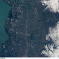
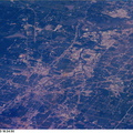
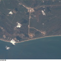
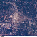
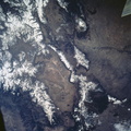
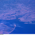
 as the Space Shuttle Columbia passed over Louisiana. In the almost vertical view, north is toward the top of the frame. New Orleans Lakefront Airport and the south end of the long causeway are recognizable features associated with Lake Poncartrain at the top of the frame. The Superdome is visible as a pinhead-sized object just below center. New Orleans International Airport is out of frame to the west (left). The Mississippi River snakes through the image from Avondale (western or left edge of frame) to Gretna (on the east or right). The photo was taken at 16:37:05 GMT, April 23, 1998.")
WIKIARCHIVES.SPACE
The Human Spaceflight Archive


Information
- Taken in
- Space
- Fotograaf/bron
- NASA
- Omschrijving
- Part of Greater New Orleans, Louisiana was captured with an electronic still camera (ESC) as the Space Shuttle Columbia passed over Louisiana. In the almost vertical view, north is toward the top of the frame. New Orleans Lakefront Airport and the south end of the long causeway are recognizable features associated with Lake Poncartrain at the top of the frame. The Superdome is visible as a pinhead-sized object just below center. New Orleans International Airport is out of frame to the west (left). The Mississippi River snakes through the image from Avondale (western or left edge of frame) to Gretna (on the east or right). The photo was taken at 16:37:05 GMT, April 23, 1998.
- Aangemaakt op
- donderdag 23 april 1998
- Albums
- US SPACE PROGRAM / SPACE SHUTTLE / MISSIONS / STS-90 / Mission Photos (Edited)
- Source link
- https://www.flickr.com/photos/nasa2explore/9362256150/in/album-72157634778874373/
- Bezoeken
- 62
- Waarderingsscore
- Geen waardering
- Waardeer deze foto
- License
- CC BY-NC
- Modified by WikiArchives
- No (original)
- Downloads
- 2
Mogelijk gemaakt door: Piwigo