
WIKIARCHIVES.SPACE
The Human Spaceflight Archive


Information
- Taken in
- Space
- Author
- NASA
- Description
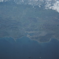
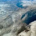
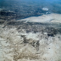
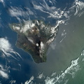
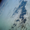
- An oblique view of northwestern Mexico, as photographed from the Skylab space station in Earth orbit by one of the Skylab 4 crewmen. The camera used was a hand-held 70mm Hasselblad, with SO-368 medium-speed Ektachrome film. This photograph was taken on a sweep down the coast to document the fault patterns of southern California and northwest Mexico. SL4-142-4532 gives an excellent overview of the entire region. The specific reason for this picture was an attempt to see if the Agua Blanca Fault in Baja California extends to the east toward the Gulf of California. Several attempts were made by the Skylab 4 crew to visually detect such an extension, but none was found. The report was that the fault disappeared into an area of sand and heavily eroded material that obscured any feature that might be present deeper. This area of sand and loose material is the light-colored area in the center of Baja at the extreme north part of the photograph. In addition to this geology the Pinacate volcanic field in Sonora, the sand dunes in Sonora, and the sediment flow patterns of the Colorado River entering the Gulf are additional areas of study utilizing this photograph.
- Created on
- Sunday 27 January 1974
- Albums
- US SPACE PROGRAM / SKYLAB / SKYLAB 4 / Mission Photos (Original)
- Source link
- https://www.flickr.com/photos/nasa2explore/albums/72157638838227374
- Visits
- 87
- Rating score
- no rate
- Rate this photo
- License
- CC BY-NC
- Modified by WikiArchives
- No (original)
- Downloads
- 0
Powered by Piwigo