 is hoisted up by crane at the mobile service tower at Space Launch Complex 2, on Aug. 26, 2018. The satellite will be attached to the top of the United Launch Alliance Delta II rocket. Launch is scheduled for Sept. 15, 2018. ICESat-2 will measure the height of a changing Earth, one laser pulse at a time, 10,000 laser pulses a second. The satellite will carry the Advanced Topographic Laser Altimeter System (ATLAS). ICESat-2 will help scientists investigate why, and how much our planet's frozen and icy areas, called the cryosphere, are changing in a warming climate.")
WIKIARCHIVES.SPACE
The Human Spaceflight Archive


Information
- Taken in
- Vandenberg
- Author
- USAF 30th Space Wing/Alex Valdez
- Description
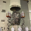
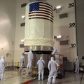
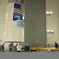
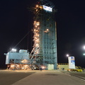
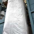
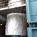
- At Vandenberg Air Force Base in California, NASA's Ice, Cloud and land Elevation Satellite-2 (ICESat-2) is hoisted up by crane at the mobile service tower at Space Launch Complex 2, on Aug. 26, 2018. The satellite will be attached to the top of the United Launch Alliance Delta II rocket. Launch is scheduled for Sept. 15, 2018. ICESat-2 will measure the height of a changing Earth, one laser pulse at a time, 10,000 laser pulses a second. The satellite will carry the Advanced Topographic Laser Altimeter System (ATLAS). ICESat-2 will help scientists investigate why, and how much our planet's frozen and icy areas, called the cryosphere, are changing in a warming climate.
- Created on
- Saturday 25 August 2018
- Albums
- US SPACE PROGRAM / SATELLITES / DELTA II / ICESat-2 / Rocket preparation
- Source link
- https://www.flickr.com/photos/nasakennedy/albums/72157694494384695/page1
- Visits
- 28
- Rating score
- no rate
- Rate this photo
- License
- CC BY-NC-ND
- Modified by WikiArchives
- No (original)
- Downloads
- 0
EXIF Metadata
NIKON CORPORATION NIKON D810
- Make
- NIKON CORPORATION
- Model
- NIKON D810
- DateTimeOriginal
- 2018:08:25 20:13:46
- ApertureFNumber
- f/9.0
Powered by Piwigo