. Liftoff was at 9:02 a.m. EDT (6:02 a.m. PDT). The satellite will measure the height of our changing Earth, one laser pulse at a time, 10,000 laser pulses per second. ICESat-2 will provide scientists with height measurements that create a global portrait of Earth's third dimension, gathering date that can precisely track changes of terrain, including glaciers, sea ice and forests.")
WIKIARCHIVES.SPACE
The Human Spaceflight Archive


Information
- Taken in
- Vandenberg
- Author
- NASA/Kim Shiflett
- Description
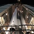
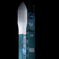
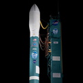
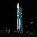
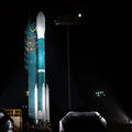
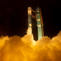
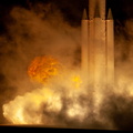
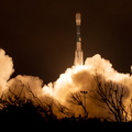
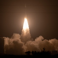
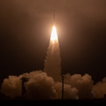
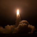
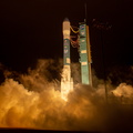
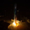
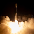
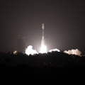
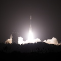
- The final United Launch Alliance Delta II rocket lifts off from Space Launch Complex 2 at Vandenberg Air Force Base in California, on Sept. 15, 2018, carrying NASA's Ice, Cloud and land Elevation Satellite-2 (ICESat-2). Liftoff was at 9:02 a.m. EDT (6:02 a.m. PDT). The satellite will measure the height of our changing Earth, one laser pulse at a time, 10,000 laser pulses per second. ICESat-2 will provide scientists with height measurements that create a global portrait of Earth's third dimension, gathering date that can precisely track changes of terrain, including glaciers, sea ice and forests.
- Created on
- Saturday 15 September 2018
- Albums
- US SPACE PROGRAM / SATELLITES / DELTA II / ICESat-2 / Mission Photos (Original) / Meanwhile, on Earth
- Source link
- https://www.flickr.com/photos/nasakennedy/albums/72157694494384695
- Visits
- 29
- Rating score
- no rate
- Rate this photo
- License
- CC BY-NC-ND
- Modified by WikiArchives
- No (original)
- Downloads
- 0
EXIF Metadata
Canon Canon EOS 5D Mark IV
- Make
- Canon
- Model
- Canon EOS 5D Mark IV
- DateTimeOriginal
- 2018:09:15 09:05:30
- ApertureFNumber
- f/8.0
Powered by Piwigo