
WIKIARCHIVES.SPACE
The Human Spaceflight Archive


Information
- Taken in
- Wallops
- Author
- NASA
- Description
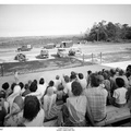
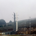
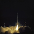
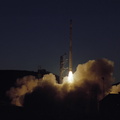
- Photograph of an Aerial View of the Launch Structure and Surrounding Buildings at the Wallops Island Launch Area in Virginia
- Created on
- Albums
- US SPACE PROGRAM / SATELLITES / SOUNDING ROCKETS / SCOUT
- Source link
- https://catalog.archives.gov/search?q=*:*&f.ancestorNaIds=18253459&sort=naIdSort%20asc&f.fileFormat=image%2Fjpeg&offset=60
- Visits
- 42
Location : 37.937447, -75.469841
- Rating score
- no rate
- Rate this photo
- License
- Public Domain
- Modified by WikiArchives
- No (original)
- Downloads
- 0
Powered by Piwigo