
WIKIARCHIVES.SPACE
The Human Spaceflight Archive


Information
- Taken in
- Space
- Author
- NASA
- Description
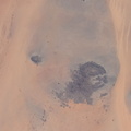
- The Paraná River, pictured from the International Space Station at an altitude of 269 miles, leads into the Paraná Delta and empties into the Rio de la Plata which separates Argentina from Uruguay on South America's Atlantic coast. The fertile lowlands region is also known as the Pampas
- Created on
- Thursday 5 May 2022
- Albums
- ISS (WIP) / EXPEDITIONS / EXPEDITION 67
- Source link
- https://www.flickr.com/photos/nasa2explore/albums/72177720297047462/
- Visits
- 26
- Rating score
- no rate
- Rate this photo
- License
- CC BY-NC-ND
- Modified by WikiArchives
- No (original)
- Downloads
- 0
EXIF Metadata
NIKON CORPORATION NIKON D5
- Make
- NIKON CORPORATION
- Model
- NIKON D5
- DateTimeOriginal
- 2022:05:05 16:00:12
- ApertureFNumber
- f/10.0
Powered by Piwigo