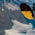
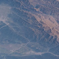
 are pictured from the International Space Station as it orbited 263 miles above the South American nation of Chile. Parinacota is a dormant volcano on the Chile-Bolivia border and its peak is about 20,800 feet. Pomerape, last active over 100,000 years ago, is also on the Chile- Bolivia border with an elevation of about 20,600 feet. At top left, is Chungará Lake in northern Chile which rests about 14,800 feet above sea level.")
WIKIARCHIVES.SPACE
The Human Spaceflight Archive


Information
- Taken in
- Space
- Author
- NASA
- Description
- The Parinacota and Pomerape stratovolcanoes (top to bottom) are pictured from the International Space Station as it orbited 263 miles above the South American nation of Chile. Parinacota is a dormant volcano on the Chile-Bolivia border and its peak is about 20,800 feet. Pomerape, last active over 100,000 years ago, is also on the Chile- Bolivia border with an elevation of about 20,600 feet. At top left, is Chungará Lake in northern Chile which rests about 14,800 feet above sea level.
- Created on
- Tuesday 21 June 2022
- Albums
- ISS (WIP) / EXPEDITIONS / EXPEDITION 67
- Source link
- https://www.flickr.com/photos/nasa2explore/albums/72177720297047462/
- Visits
- 25
- Rating score
- no rate
- Rate this photo
- License
- CC BY-NC-ND
- Modified by WikiArchives
- No (original)
- Downloads
- 1
EXIF Metadata
NIKON CORPORATION NIKON D5
- Make
- NIKON CORPORATION
- Model
- NIKON D5
- DateTimeOriginal
- 2022:06:21 20:43:17
- ApertureFNumber
- f/14.0
Powered by Piwigo