
WIKIARCHIVES.SPACE
The Human Spaceflight Archive


Information
- Taken in
- Space
- Author
- NASA
- Description
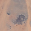
- The Richat Structure, also known as the "Eye of the Sahara," an eroded geological dome in the nation of Mauritania, is pictured from the International Space Station as it orbited 256 miles above northwestern Africa.
- Created on
- Saturday 20 August 2022
- Albums
- ISS (WIP) / EXPEDITIONS / EXPEDITION 67
- Source link
- https://www.flickr.com/photos/nasa2explore/albums/72177720297047462/
- Visits
- 28
- Rating score
- no rate
- Rate this photo
- License
- CC BY-NC-ND
- Modified by WikiArchives
- No (original)
- Downloads
- 0
EXIF Metadata
NIKON CORPORATION NIKON D5
- Make
- NIKON CORPORATION
- Model
- NIKON D5
- DateTimeOriginal
- 2022:08:20 14:51:56
- ApertureFNumber
- f/16.0
Powered by Piwigo