
WIKIARCHIVES.SPACE
The Human Spaceflight Archive
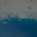
This nadir picture of Galveston Island and its coastline on the Gulf of Mexico was taken by one of the Expedition 39 crew members aboard the International Space Station on March 12. It was among the first batch of Earth photographs downlinked near the beginning of the Expedition 38 mission. The clear weather and the 800mm focal length used to record the photo allow for very detailed "bird's eye" viewing of the storied city. The Interstate 45 causeway can be seen at bottom center, and Scholes International Airport is seen nearby.


Information
- Taken in
- Space
- Author
- NASA
- Description
-
This nadir picture of Galveston Island and its coastline on the Gulf of Mexico was taken by one of the Expedition 39 crew members aboard the International Space Station on March 12. It was among the first batch of Earth photographs downlinked near the beginning of the Expedition 38 mission. The clear weather and the 800mm focal length used to record the photo allow for very detailed "bird's eye" viewing of the storied city. The Interstate 45 causeway can be seen at bottom center, and Scholes International Airport is seen nearby.
The Bolivar Island ferry landing is just out of frame at bottom left.
- Created on
- Wednesday 12 March 2014
- Albums
- ISS (WIP) / EXPEDITIONS / EXPEDITION 39
- Source link
- https://www.flickr.com/photos/nasa2explore/albums/72157634179653666
- Visits
- 17
- Rating score
- no rate
- Rate this photo
- License
- CC BY-NC-ND
- Modified by WikiArchives
- No (original)
- Downloads
- 0
EXIF Metadata
NIKON CORPORATION NIKON D3S
- Make
- NIKON CORPORATION
- Model
- NIKON D3S
- DateTimeOriginal
- 2014:03:12 19:38:42
- ApertureFNumber
- f/6.3
Powered by Piwigo