 and two darker zones where the tallest buildings in Midtown East and the Financial District cast strong shadows, even in this early afternoon view. Rivers and parks reduce the effect of the urban heat island – the local zone of higher surface and atmospheric temperatures generated by storage and later release of heat by city materials such as concrete and tarmac. Rivers provide pathways for wind and the cooling effect of parks is detectable by instruments on spacecraft that can measure the temperature of the ground surface. Tall buildings have a more complex effect. Shadowed zones in the urban canyons between tall buildings – as shown in this image – receive fewer hours of direct sun per day. But where the sun can reach canyon floors, the sun's energy is reflected back up at the walls of the buildings where it is absorbed and later released as heat. This is especially the case at night when urban canyons retain more heat than those sections of the city with shorter buildings.")
WIKIARCHIVES.SPACE
The Human Spaceflight Archive


Information
- Taken in
- Space
- Author
- NASA
- Description
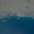
- New York City is featured in this image photographed by an Expedition 39 crew member on the International Space Station. This detailed image reveals the narrow shape of Manhattan located between the Hudson River and the East River, a feature familiar to crews on the space station. The ragged line of shadow cast by the Palisades cliff crosses the bottom of the image. Wharves jut into the rivers; bridges are visible mainly because of the shadows they cast, and the grid pattern of major roads stands out. On the island of Manhattan itself the main visual features are Central Park (with playing fields as white dots) and two darker zones where the tallest buildings in Midtown East and the Financial District cast strong shadows, even in this early afternoon view. Rivers and parks reduce the effect of the urban heat island – the local zone of higher surface and atmospheric temperatures generated by storage and later release of heat by city materials such as concrete and tarmac. Rivers provide pathways for wind and the cooling effect of parks is detectable by instruments on spacecraft that can measure the temperature of the ground surface. Tall buildings have a more complex effect. Shadowed zones in the "urban canyons" between tall buildings – as shown in this image – receive fewer hours of direct sun per day. But where the sun can reach canyon floors, the sun's energy is reflected back up at the walls of the buildings where it is absorbed and later released as heat. This is especially the case at night when urban canyons retain more heat than those sections of the city with shorter buildings.
- Created on
- Monday 5 May 2014
- Albums
- ISS (WIP) / EXPEDITIONS / EXPEDITION 39
- Source link
- https://www.flickr.com/photos/nasa2explore/albums/72157634179653666
- Visits
- 19
- Rating score
- no rate
- Rate this photo
- License
- CC BY-NC-ND
- Modified by WikiArchives
- No (original)
- Downloads
- 0
EXIF Metadata
NIKON CORPORATION NIKON D3S
- Make
- NIKON CORPORATION
- Model
- NIKON D3S
- DateTimeOriginal
- 2014:05:05 19:53:19
- ApertureFNumber
- f/8.0
Powered by Piwigo