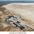
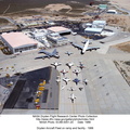
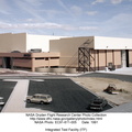
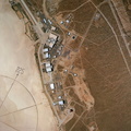
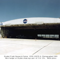
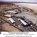
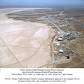
 constructed in 1954. Since then many additional support and operational facilities have been built. Among the most prominent are the space shuttle program's Mate-Demate structure and hangar in Area A (upper right) to the north of the main complex.
The Dryden complex originated at Edwards in support of the X-1 supersonic flight program. As other high-speed aircraft entered research programs, the facility became permanent and grew from an original staff of five engineers in 1947 to a population in 1995 of about 900 full-time government and contractor employees.")
WIKIARCHIVES.SPACE
The Human Spaceflight Archive
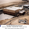
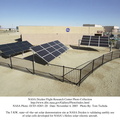
The concrete aircraft parking and taxiway facilities loom prominently in an aerial photograph of the NASA Dryden Flight Research Center, located on the northwest edge of Rogers Dry Lake at Edwards AFB, California. The complex is built around the original administrative-hangar building (center) constructed in 1954. Since then many additional support and operational facilities have been built. Among the most prominent are the space shuttle program's Mate-Demate structure and hangar in Area A (upper right) to the north of the main complex.


Information
- Taken in
- Edwards Air Force Base
- Author
- NASA
- Description
-
The concrete aircraft parking and taxiway facilities loom prominently in an aerial photograph of the NASA Dryden Flight Research Center, located on the northwest edge of Rogers Dry Lake at Edwards AFB, California. The complex is built around the original administrative-hangar building (center) constructed in 1954. Since then many additional support and operational facilities have been built. Among the most prominent are the space shuttle program's Mate-Demate structure and hangar in Area A (upper right) to the north of the main complex.
The Dryden complex originated at Edwards in support of the X-1 supersonic flight program. As other high-speed aircraft entered research programs, the facility became permanent and grew from an original staff of five engineers in 1947 to a population in 1995 of about 900 full-time government and contractor employees.
- Created on
- Albums
- US SPACE PROGRAM / FACILITIES / DRYDEN/ARMSTRONG CENTER
- Source link
- https://www.dfrc.nasa.gov/Gallery/Photo/Places/index.html
- Visits
- 17
- Rating score
- no rate
- Rate this photo
- License
- Public Domain
- Modified by WikiArchives
- No (original)
- Downloads
- 0
Powered by Piwigo