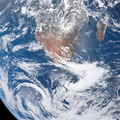
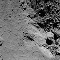
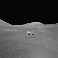
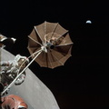
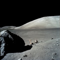
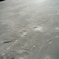
 west across Mare Serentatis from the Taurus-Littrow landing site where scientist-astronaut Harrison H. Jack Schmitt, lunar module pilot, discovered an orange soil sample composed of fine glass particles rich in iron and titanium. North is toward the right. Rima Sulpicius Gallus is the lunar trench or valley (right foreground) that crosses the edge of the Mare and divides into three branches as it runs to the northwest. The crater Sulpicius Gallus is just off the photograph at the bottom right. Note that several small craters in the dark portion of the picture (east) show a more distinct orange cast. The coordinates of the center of this photograph are about 8.4 degrees east longitude and 19.8 degrees north latitude.")
WIKIARCHIVES.SPACE
The Human Spaceflight Archive


Information
- Taken in
- Moon Orbit
- Author
- NASA
- Description
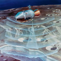
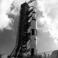
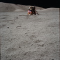
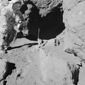
- An oblique view of the Sulpicius Gallus region on the southwestern edge of the Sea of Serenity looking westward across the Haemus Mountains, as photographed from the Apollo 17 Command and Service Modules during its 65th revolution of the moon. This photograph shows the slight orange cast which was identified by astronaut Ronald E. Evans, command module pilot. The region shown in the picture is about 600 kilometers (360 statute miles) west across Mare Serentatis from the Taurus-Littrow landing site where scientist-astronaut Harrison H. "Jack" Schmitt, lunar module pilot, discovered an orange soil sample composed of fine glass particles rich in iron and titanium. North is toward the right. Rima Sulpicius Gallus is the lunar trench or valley (right foreground) that crosses the edge of the Mare and divides into three branches as it runs to the northwest. The crater Sulpicius Gallus is just off the photograph at the bottom right. Note that several small craters in the dark portion of the picture (east) show a more distinct orange cast. The coordinates of the center of this photograph are about 8.4 degrees east longitude and 19.8 degrees north latitude.
- Created on
- Friday 15 December 1972
- Albums
- US SPACE PROGRAM / APOLLO / APOLLO 17 / Mission Photos (Edited)
- Source link
- https://www.flickr.com/photos/nasa2explore/9361438360/in/album-72157634777421773/
- Visits
- 174
- Rating score
- no rate
- Rate this photo
- License
- Public Domain
- Modified by WikiArchives
- No (original)
- Downloads
- 0
Powered by Piwigo