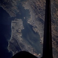
 view. The scene covers from Redondo Beach on the left to Seal Beach on the right; from San Pedro at bottom to the Torrance-Gardena area at top.")
WIKIARCHIVES.SPACE
The Human Spaceflight Archive


Information
- Taken in
- Space
- Author
- NASA
- Description
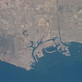
- The port of the Queen Mary ocean liner is near bottom right center in this Electronic Still Camera (ESC) view. The scene covers from Redondo Beach on the left to Seal Beach on the right; from San Pedro at bottom to the Torrance-Gardena area at top.
- Created on
- Monday 30 October 1995
- Albums
- US SPACE PROGRAM / SPACE SHUTTLE / MISSIONS / STS-73 / Mission Photos (Edited)
- Source link
- https://www.flickr.com/photos/nasa2explore/9357281297/in/album-72157634781092624/
- Visits
- 58
- Rating score
- no rate
- Rate this photo
- License
- CC BY-NC
- Modified by WikiArchives
- No (original)
- Downloads
- 0
EXIF Metadata
KODAK DCS460A FILE VERSION 3 050995 GPS-NASA
- Make
- KODAK
- Model
- DCS460A FILE VERSION 3 050995 GPS-NASA
Powered by Piwigo