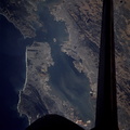
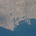
, Dumbarton, San Mateo, Bay, Golden Gate, and San Rafael bridges are seen. Ribbons of run-off induced sediments color the bay, and multi-colored salt-production pens line the southernmost shore.")
WIKIARCHIVES.SPACE
The Human Spaceflight Archive


Information
- Taken in
- Space
- Author
- NASA
- Description
- Each of the great bridges spanning San Francisco Bay are captured in this near-nadir photo of the San Francisco and Oakland, California, areas. Starting from the south (left in this photo), Dumbarton, San Mateo, Bay, Golden Gate, and San Rafael bridges are seen. Ribbons of run-off induced sediments color the bay, and multi-colored salt-production pens line the southernmost shore.
- Created on
- Sunday 22 October 1995
- Albums
- US SPACE PROGRAM / SPACE SHUTTLE / MISSIONS / STS-73 / Mission Photos (Edited)
- Source link
- https://www.flickr.com/photos/nasa2explore/9359880398/in/album-72157634781092624/
- Visits
- 64
- Rating score
- no rate
- Rate this photo
- License
- CC BY-NC
- Modified by WikiArchives
- No (original)
- Downloads
- 0
Powered by Piwigo