
WIKIARCHIVES.SPACE
The Human Spaceflight Archive


Information
- Taken in
- Space
- Author
- NASA
- Description
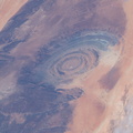
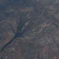
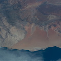
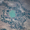
- From an altitude of 255 miles, an Expedition 59 crewmember photographed the Richat Structure, or the "Eye of the Sahara," in northwestern Mauritania. The circular geologic feature is thought to be caused by an uplifted dome—geologists would classify it as a domed anticline—that has been eroded to expose the originally flat rock layers.
- Created on
- Friday 5 April 2019
- Albums
- ISS (WIP) / EXPEDITIONS / EXPEDITION 59
- Source link
- https://www.flickr.com/photos/nasa2explore/albums/72157684823968065
- Visits
- 21
- Rating score
- no rate
- Rate this photo
- License
- CC BY-NC-ND
- Modified by WikiArchives
- No (original)
- Downloads
- 0
EXIF Metadata
NIKON CORPORATION NIKON D5
- Make
- NIKON CORPORATION
- Model
- NIKON D5
- DateTimeOriginal
- 2019:04:05 13:09:28
- ApertureFNumber
- f/16.0
Powered by Piwigo