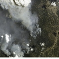
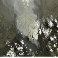
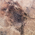
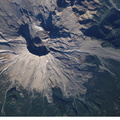
. On May 18, 1980, Mount Saint Helens volcano erupted. A series of earthquakes preceded the eruption, triggering a collapse of the north side of the mountain into a massive landslide. This avalanche coincided with a huge explosion that destroyed over 270 square miles of forest in a few seconds, and sent a billowing cloud of ash and smoke 80,000 feet into the atmosphere. The crewmembers on the Station captured this detailed image of the volcano’s summit caldera. In the center of the crater sits a lava dome that is 876 feet above the crater floor and is about 3,500 feet in diameter. The upper slopes of the 1980 blast zone begin at the gray colored region that extends north (upper left) from the summit of the volcano. The deeply incised valley to the left (west) is the uppermost reach of the South Fork of the Toutle River. Devastating mudslides buried the original Toutle River Valley to an average depth of 150 feet, but in places up to 600 feet. The dark green area south of the blast zone is the thickly forested region of the Gifford Pinchot National Forest.")
WIKIARCHIVES.SPACE
The Human Spaceflight Archive


Information
- Taken in
- Space
- Author
- NASA
- Description
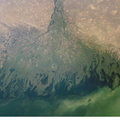
- Mount Saint Helens, Washington, is featured in this image photographed by an Expedition 5 crewmember on the International Space Station (ISS). On May 18, 1980, Mount Saint Helens volcano erupted. A series of earthquakes preceded the eruption, triggering a collapse of the north side of the mountain into a massive landslide. This avalanche coincided with a huge explosion that destroyed over 270 square miles of forest in a few seconds, and sent a billowing cloud of ash and smoke 80,000 feet into the atmosphere. The crewmembers on the Station captured this detailed image of the volcano’s summit caldera. In the center of the crater sits a lava dome that is 876 feet above the crater floor and is about 3,500 feet in diameter. The upper slopes of the 1980 blast zone begin at the gray colored region that extends north (upper left) from the summit of the volcano. The deeply incised valley to the left (west) is the uppermost reach of the South Fork of the Toutle River. Devastating mudslides buried the original Toutle River Valley to an average depth of 150 feet, but in places up to 600 feet. The dark green area south of the blast zone is the thickly forested region of the Gifford Pinchot National Forest.
- Created on
- Friday 25 October 2002
- Albums
- ISS (WIP) / EXPEDITIONS / EXPEDITION 05
- Source link
- https://www.flickr.com/photos/nasa2explore/albums/72157635065835713
- Visits
- 59
- Rating score
- no rate
- Rate this photo
- License
- CC BY-NC-ND
- Modified by WikiArchives
- No (original)
- Downloads
- 0
Powered by Piwigo