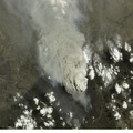
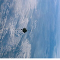
 during its fifth staffing, depicts both agriculture and the petroleum industry, which compete for land use near Denver City, Texas. The photo was recently released by the Earth Sciences and Image Analysis Laboratory at Johnson Space Center. The area is southwest of Lubbock near the New Mexico border. According to analysts studying the station imagery, the economy of this region is almost completely dependent on its underground resources of petroleum and water. Both resources result in distinctive land use patterns visible from space. Historically this area has produced vast quantities of oil and gas since development began in the 1930s. A fine, light-colored grid of roads and pipelines connect well sites over this portion of the Wasson Oil Field, one of the state’s most productive. Since the 1940s, agricultural land use has shifted from grazing to irrigated cultivation of cotton, sorghum, wheat, hay, and corn. The water supply is drawn from wells tapping the vast Ogallala Aquifer. Note the large, circular center-pivot irrigation systems in the lower corners of the image. The largest is nearly a mile in diameter.")
WIKIARCHIVES.SPACE
The Human Spaceflight Archive


Information
- Taken in
- Space
- Author
- NASA
- Description
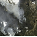
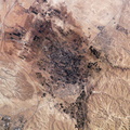
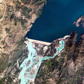
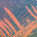
- This digital still photograph, taken from the International Space Station (ISS) during its fifth staffing, depicts both agriculture and the petroleum industry, which compete for land use near Denver City, Texas. The photo was recently released by the Earth Sciences and Image Analysis Laboratory at Johnson Space Center. The area is southwest of Lubbock near the New Mexico border. According to analysts studying the station imagery, the economy of this region is almost completely dependent on its underground resources of petroleum and water. Both resources result in distinctive land use patterns visible from space. Historically this area has produced vast quantities of oil and gas since development began in the 1930s. A fine, light-colored grid of roads and pipelines connect well sites over this portion of the Wasson Oil Field, one of the state’s most productive. Since the 1940s, agricultural land use has shifted from grazing to irrigated cultivation of cotton, sorghum, wheat, hay, and corn. The water supply is drawn from wells tapping the vast Ogallala Aquifer. Note the large, circular center-pivot irrigation systems in the lower corners of the image. The largest is nearly a mile in diameter.
- Created on
- Saturday 17 August 2002
- Albums
- ISS (WIP) / EXPEDITIONS / EXPEDITION 05
- Source link
- https://www.flickr.com/photos/nasa2explore/albums/72157635065835713
- Visits
- 58
- Rating score
- no rate
- Rate this photo
- License
- CC BY-NC-ND
- Modified by WikiArchives
- No (original)
- Downloads
- 0
Powered by Piwigo