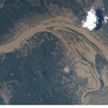
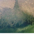
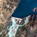
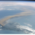
. The photographs show flooding around the Danube Bend area just north of Budapest near the city of Vác, Hungary. The flood peaked in Budapest four days before this photo was made, on August 19, at about 8.5 meters (28 feet), exceeding the previous 1965 flood record. Water had begun to recede when this image was made. Image no. ISS005-E-10000 shows the area four days earlier.")
WIKIARCHIVES.SPACE
The Human Spaceflight Archive


Information
- Taken in
- Space
- Author
- NASA
- Description
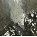
- This is the second of two images recently released by the Earth Sciences and Image Analysis Laboratory at Johnson Space Center, showing some of the devastating late summer 2002 European flooding. The images were captured by astronauts using a digital still camera onboard the International Space Station (ISS). The photographs show flooding around the Danube Bend area just north of Budapest near the city of Vác, Hungary. The flood peaked in Budapest four days before this photo was made, on August 19, at about 8.5 meters (28 feet), exceeding the previous 1965 flood record. Water had begun to recede when this image was made. Image no. ISS005-E-10000 shows the area four days earlier.
- Created on
- Friday 23 August 2002
- Albums
- ISS (WIP) / EXPEDITIONS / EXPEDITION 05
- Source link
- https://www.flickr.com/photos/nasa2explore/albums/72157635065835713
- Visits
- 55
- Rating score
- no rate
- Rate this photo
- License
- CC BY-NC-ND
- Modified by WikiArchives
- No (original)
- Downloads
- 0
Powered by Piwigo