. The central lake in this image is one of hundreds in the Ibera swamplands that were formed by South America’s second largest river, the Parana. Although this great river now lies 120 kilometers to the north, its channel has swung over a great “inland delta” in the recent geological past, according to NASA scientists studying the Expedition 10 photo collection. This and other lakes were captured in this photograph as the sunglint point passed over this remote but vast swampland in northeast Argentina. The glint pattern shows winds ruffling the water surfaces. The lakes in this image lie within side channels of the Parana formed when it flowed through this region. The central lake in the image is about 2 kilometers long. Forest, swamp and prairie vegetation types outline the low topography which consists of lakes, low swells and depressions.")
WIKIARCHIVES.SPACE
The Human Spaceflight Archive


Information
- Taken in
- Space
- Author
- NASA
- Description
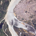
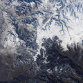
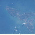
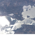
- Ibera Swamp topography in northeast Argentina is featured in this image photographed by an Expedition 10 crewmember on the International Space Station (ISS). The central lake in this image is one of hundreds in the Ibera swamplands that were formed by South America’s second largest river, the Parana. Although this great river now lies 120 kilometers to the north, its channel has swung over a great “inland delta” in the recent geological past, according to NASA scientists studying the Expedition 10 photo collection. This and other lakes were captured in this photograph as the sunglint point passed over this remote but vast swampland in northeast Argentina. The glint pattern shows winds ruffling the water surfaces. The lakes in this image lie within side channels of the Parana formed when it flowed through this region. The central lake in the image is about 2 kilometers long. Forest, swamp and prairie vegetation types outline the low topography which consists of lakes, low swells and depressions.
- Created on
- Monday 25 October 2004
- Albums
- ISS (WIP) / EXPEDITIONS / EXPEDITION 10
- Source link
- https://www.flickr.com/photos/nasa2explore/albums/72157634802502630
- Visits
- 22
- Rating score
- no rate
- Rate this photo
- License
- CC BY-NC-ND
- Modified by WikiArchives
- No (original)
- Downloads
- 1
Powered by Piwigo