. Green circles in the desert frequently indicate tracts of agriculture supported by center-pivot irrigation. The Al Khufrah Oasis in southeastern Libya (near the Egyptian border) is one of Libya’s largest agricultural projects, and is an easy-to-recognize landmark for orbiting crewmembers aboard the Station. The center-pivot irrigation system pumps water under pressure into a gantry or tubular arm from a central source. Anchored by a central pivot, the gantry slowly rotates over the area to be irrigated, thereby producing the circular patterns. Although the field diameters vary, these fields are approximately 0.6 mile (1 kilometer) in diameter. Darker colors indicate fields where such crops as wheat and alfalfa are grown. Lighter colors can indicate a variety of agricultural processes: fields that have been harvested recently; fields that are lying fallow; fields that have just been planted; or fields that have been taken out of production.")
WIKIARCHIVES.SPACE
The Human Spaceflight Archive


Information
- Taken in
- Space
- Author
- NASA
- Description
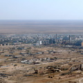
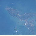
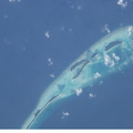
- The Al Khufrah Oasis is featured in this image photographed by an Expedition 10 crewmember on the International Space Station (ISS). Green circles in the desert frequently indicate tracts of agriculture supported by center-pivot irrigation. The Al Khufrah Oasis in southeastern Libya (near the Egyptian border) is one of Libya’s largest agricultural projects, and is an easy-to-recognize landmark for orbiting crewmembers aboard the Station. The center-pivot irrigation system pumps water under pressure into a gantry or tubular arm from a central source. Anchored by a central pivot, the gantry slowly rotates over the area to be irrigated, thereby producing the circular patterns. Although the field diameters vary, these fields are approximately 0.6 mile (1 kilometer) in diameter. Darker colors indicate fields where such crops as wheat and alfalfa are grown. Lighter colors can indicate a variety of agricultural processes: fields that have been harvested recently; fields that are lying fallow; fields that have just been planted; or fields that have been taken out of production.
- Created on
- Thursday 28 October 2004
- Albums
- ISS (WIP) / EXPEDITIONS / EXPEDITION 10
- Source link
- https://www.flickr.com/photos/nasa2explore/albums/72157634802502630
- Visits
- 21
- Rating score
- no rate
- Rate this photo
- License
- CC BY-NC-ND
- Modified by WikiArchives
- No (original)
- Downloads
- 0
Powered by Piwigo