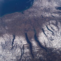
. Shapes of the snow-covered hills are accented by the low sun angles, and contrast with the darker, finger-shaped lakes filling the region’s valleys. Scientists believe the steep, roughly parallel valleys and hills of the Finger Lakes region were shaped by advancing and retreating ice sheets that were as much as 2 miles deep during the last ice age. River valleys were scoured into deep troughs; many are now filled with lakes. The two largest lakes, Seneca and Cayuga, are so deep that the bases of their lakebeds are below sea level. The cities of Rochester, Syracuse and Ithaca are included in this field-of-view, as seen from the Space Station. These three cities enjoy large seasonal snowpacks, thanks to the influence of the Great Lakes producing lake-effect snowstorms. According to NASA scientists studying the Space Station imagery, despite its reputation for long winters, the region is balmy compared with the glacial climate present when the landscape was carved. Scientists believe, at the time of the greatest ice extent, yearly average temperatures over northern North America were several degrees lower than today.")
WIKIARCHIVES.SPACE
The Human Spaceflight Archive


Information
- Taken in
- Space
- Author
- NASA
- Description
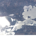
- New York’s Finger Lakes region is featured in this digital image photographed by an Expedition 10 crewmember on the International Space Station (ISS). Shapes of the snow-covered hills are accented by the low sun angles, and contrast with the darker, finger-shaped lakes filling the region’s valleys. Scientists believe the steep, roughly parallel valleys and hills of the Finger Lakes region were shaped by advancing and retreating ice sheets that were as much as 2 miles deep during the last ice age. River valleys were scoured into deep troughs; many are now filled with lakes. The two largest lakes, Seneca and Cayuga, are so deep that the bases of their lakebeds are below sea level. The cities of Rochester, Syracuse and Ithaca are included in this field-of-view, as seen from the Space Station. These three cities enjoy large seasonal snowpacks, thanks to the influence of the Great Lakes producing lake-effect snowstorms. According to NASA scientists studying the Space Station imagery, despite its reputation for long winters, the region is balmy compared with the glacial climate present when the landscape was carved. Scientists believe, at the time of the greatest ice extent, yearly average temperatures over northern North America were several degrees lower than today.
- Created on
- Saturday 4 December 2004
- Albums
- ISS (WIP) / EXPEDITIONS / EXPEDITION 10
- Source link
- https://www.flickr.com/photos/nasa2explore/albums/72157634802502630
- Visits
- 20
- Rating score
- no rate
- Rate this photo
- License
- CC BY-NC-ND
- Modified by WikiArchives
- No (original)
- Downloads
- 0
Powered by Piwigo