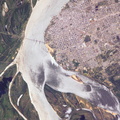
. FM528 goes horizontally through the middle, and FM518 runs vertically through frame center, with the two roads intersecting near Friendswood.")
WIKIARCHIVES.SPACE
The Human Spaceflight Archive


Information
- Taken in
- Space
- Author
- NASA
- Description
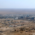
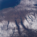
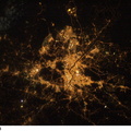
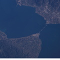
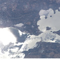
- The border of Galveston and Brazoria Counties in Texas is visible in this electronic still camera's image, as photographed by the Expedition 10 crew onboard the International Space Station. Polly Ranch, near Friendswood, is visible west of Interstate Highway 45 (right side). FM528 goes horizontally through the middle, and FM518 runs vertically through frame center, with the two roads intersecting near Friendswood.
- Created on
- Monday 17 January 2005
- Albums
- ISS (WIP) / EXPEDITIONS / EXPEDITION 10
- Source link
- https://www.flickr.com/photos/nasa2explore/albums/72157634802502630
- Visits
- 21
- Rating score
- no rate
- Rate this photo
- License
- CC BY-NC-ND
- Modified by WikiArchives
- No (original)
- Downloads
- 0
Powered by Piwigo