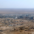
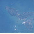
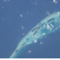
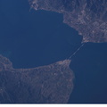
 is featured in this image photographed by an Expedition 10 crewmember on the International Space Station (ISS). On December 26, 2004 a large (magnitude 9.0) earthquake occurred off the western coast of Sumatra in the Indian Ocean. Scientists believe the earthquake was caused by the release of stresses accumulated as the India tectonic plate is overridden by the Burma tectonic plate. Movement of the seafloor due to the earthquake generated a tsunami, or seismic sea wave, that affected coastal regions around the Indian Ocean. The northwestern Sumatra coastline in particular suffered extensive damage and loss of life. This photo, along with image ISS010-E-13088, illustrates damage along the southwestern coast of Aceh Province in the vicinity of the city of Lho’ Kruet, Indonesia. Large areas of bare and disturbed soil (brownish gray) previously covered with vegetation are visible along the coastline. Embayments in the coastline were particularly hard hit, while adjacent headlands were less affected.")
WIKIARCHIVES.SPACE
The Human Spaceflight Archive


Information
- Taken in
- Space
- Author
- NASA
- Description
- Tsunami damage, northwestern Sumatra (Indonesia) is featured in this image photographed by an Expedition 10 crewmember on the International Space Station (ISS). On December 26, 2004 a large (magnitude 9.0) earthquake occurred off the western coast of Sumatra in the Indian Ocean. Scientists believe the earthquake was caused by the release of stresses accumulated as the India tectonic plate is overridden by the Burma tectonic plate. Movement of the seafloor due to the earthquake generated a tsunami, or seismic sea wave, that affected coastal regions around the Indian Ocean. The northwestern Sumatra coastline in particular suffered extensive damage and loss of life. This photo, along with image ISS010-E-13088, illustrates damage along the southwestern coast of Aceh Province in the vicinity of the city of Lho’ Kruet, Indonesia. Large areas of bare and disturbed soil (brownish gray) previously covered with vegetation are visible along the coastline. Embayments in the coastline were particularly hard hit, while adjacent headlands were less affected.
- Created on
- Saturday 15 January 2005
- Albums
- ISS (WIP) / EXPEDITIONS / EXPEDITION 10
- Source link
- https://www.flickr.com/photos/nasa2explore/albums/72157634802502630
- Visits
- 24
- Rating score
- no rate
- Rate this photo
- License
- CC BY-NC-ND
- Modified by WikiArchives
- No (original)
- Downloads
- 1
Powered by Piwigo