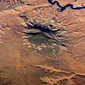
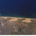
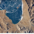
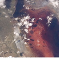
, one of several in southeast Utah that intrude and uplift the surrounding sedimentary layers of the Plateau. This oblique image highlights Navajo Mountain in the center of the image, surrounded by light red-brown Navajo Sandstone (also visible in canyons at bottom of image). Scientists believe the peak of Navajo Mountain, at approximately 3148 meters (10,388 feet) elevation, is comprised of uplifted Dakota Sandstone deposited during the Cretaceous Period. The establishment of Rainbow Bridge National Monument (1910), and the filling of Glen Canyon by Lake Powell in 1963 (upper right), have facilitated tourism and aesthetic appreciation of this previously remote region. Access to Navajo Mountain is still regulated by the sovereign Navajo Nation, and the process of permitting is required to hike in the region.")
WIKIARCHIVES.SPACE
The Human Spaceflight Archive


Information
- Taken in
- Space
- Author
- NASA
- Description
- Navajo Mountain, Utah is featured in this image photographed by an Expedition 12 crewmember on the international space station. According to scientists, the Colorado Plateau of Arizona, Colorado, New Mexico, and Utah is characterized by mostly flat-lying sedimentary layers that record paleoclimate extremes ranging from oceans to widespread deserts over the last 1.8 billion years. Navajo Mountain is formed by a dome-shaped body of igneous rock (called a laccolith by geologists), one of several in southeast Utah that intrude and uplift the surrounding sedimentary layers of the Plateau. This oblique image highlights Navajo Mountain in the center of the image, surrounded by light red-brown Navajo Sandstone (also visible in canyons at bottom of image). Scientists believe the peak of Navajo Mountain, at approximately 3148 meters (10,388 feet) elevation, is comprised of uplifted Dakota Sandstone deposited during the Cretaceous Period. The establishment of Rainbow Bridge National Monument (1910), and the filling of Glen Canyon by Lake Powell in 1963 (upper right), have facilitated tourism and aesthetic appreciation of this previously remote region. Access to Navajo Mountain is still regulated by the sovereign Navajo Nation, and the process of permitting is required to hike in the region.
- Created on
- Friday 14 October 2005
- Albums
- ISS (WIP) / EXPEDITIONS / EXPEDITION 12
- Source link
- https://www.flickr.com/photos/nasa2explore/albums/72157634842026003
- Visits
- 14
- Rating score
- no rate
- Rate this photo
- License
- CC BY-NC-ND
- Modified by WikiArchives
- No (original)
- Downloads
- 0
Powered by Piwigo