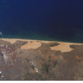
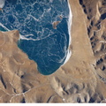
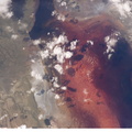
 while leaving harder rocks (such as limestone and dolomite) to form the linear ridges of the mountains. The depositional environment and tectonic history of the rocks was conducive to the formation and trapping of petroleum, and the Zagros region is an important part of Persian Gulf production. This image of the southwestern edge of the Zagros mountain belt includes another common feature of the region – a salt dome (“Kuh-e-Namak” or “mountain of salt” in Farsi). Thick layers of minerals such as halite (common table salt) typically accumulate in closed basins during alternating wet and dry climatic conditions. Over geologic time, the scientists say, these layers of salt are buried under overburden of younger layers of rock. The overburden pressure causes the lower-density salt to flow upwards, bending the overlaying rock layers and creating a dome-like structure. Erosion has spectacularly revealed the uplifted tan and brown rock layers surrounding the white Kuh-e-Namak to the northwest and southeast (center of image). Radial drainage patterns indicate another salt dome is located to the southwest (image left center). If the rising plug of salt (called a salt diapir) breaches the surface, it can become a flowing salt glacier. Salt domes are an important target for oil exploration, as the impermeable salt frequently traps petroleum beneath other rock layers.")
WIKIARCHIVES.SPACE
The Human Spaceflight Archive


Information
- Taken in
- Space
- Author
- NASA
- Description
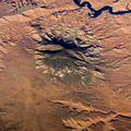
- Salt Dome in the Zagros Mountains, Iran is featured in this image photographed by an Expedition 12 crew member on the International Space Station. The Zagros Mountains in southwestern Iran present an impressive landscape of long linear ridges and valleys extending hundreds of kilometers, formed by collision of the Asian and Arabian tectonic plates. According to scientists, stresses induced in the Earth’s crust by the collision caused extensive folding of the preexisting layered sedimentary rocks, with subsequent differential erosion removing softer rocks (such as siltstone and mudstone) while leaving harder rocks (such as limestone and dolomite) to form the linear ridges of the mountains. The depositional environment and tectonic history of the rocks was conducive to the formation and trapping of petroleum, and the Zagros region is an important part of Persian Gulf production. This image of the southwestern edge of the Zagros mountain belt includes another common feature of the region – a salt dome (“Kuh-e-Namak” or “mountain of salt” in Farsi). Thick layers of minerals such as halite (common table salt) typically accumulate in closed basins during alternating wet and dry climatic conditions. Over geologic time, the scientists say, these layers of salt are buried under overburden of younger layers of rock. The overburden pressure causes the lower-density salt to flow upwards, bending the overlaying rock layers and creating a dome-like structure. Erosion has spectacularly revealed the uplifted tan and brown rock layers surrounding the white Kuh-e-Namak to the northwest and southeast (center of image). Radial drainage patterns indicate another salt dome is located to the southwest (image left center). If the rising plug of salt (called a salt diapir) breaches the surface, it can become a flowing salt glacier. Salt domes are an important target for oil exploration, as the impermeable salt frequently traps petroleum beneath other rock layers.
- Created on
- Tuesday 28 February 2006
- Albums
- ISS (WIP) / EXPEDITIONS / EXPEDITION 12
- Source link
- https://www.flickr.com/photos/nasa2explore/albums/72157634842026003
- Visits
- 17
- Rating score
- no rate
- Rate this photo
- License
- CC BY-NC-ND
- Modified by WikiArchives
- No (original)
- Downloads
- 0
Powered by Piwigo