 in this view. The bay leads out into southern Lake Erie (top). The small city of Sandusky occupies the northeastern shore of the bay (center of the image). Highway 6 can be seen arcing around the south side of the city. Ferries connect Sandusky to Pelee Island (not visible) in the middle of the lake. In earlier days, Sandusky Bay was known as one of the best protected port sites in the Great Lakes. The most striking aspect of this image is the flow lines of the brown water in and out of the mouth of the bay. Slight movement of lake surface water, driven mainly by wind, causes a small ebb and flow of bay water. Sediment-charged water is derived from agricultural fields along the Sandusky River upstream. Mud plumes in Lake Erie originate from prior pulses of muddy water from the bay. According to scientists studying the station photos, it appears that water was flowing into the bay when this image was taken. Sandusky lies midway between Toledo and Cleveland, both about an hour’s drive away.")
WIKIARCHIVES.SPACE
The Human Spaceflight Archive


Information
- Taken in
- Space
- Author
- NASA
- Description
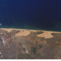
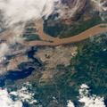
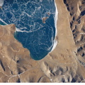
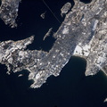
- Sandusky Bay is featured in this image photographed by an Expedition 12 crew member on the International Space Station. Sandusky Bay appears with brown muddy water (left) in this view. The bay leads out into southern Lake Erie (top). The small city of Sandusky occupies the northeastern shore of the bay (center of the image). Highway 6 can be seen arcing around the south side of the city. Ferries connect Sandusky to Pelee Island (not visible) in the middle of the lake. In earlier days, Sandusky Bay was known as one of the best protected port sites in the Great Lakes. The most striking aspect of this image is the flow lines of the brown water in and out of the mouth of the bay. Slight movement of lake surface water, driven mainly by wind, causes a small ebb and flow of bay water. Sediment-charged water is derived from agricultural fields along the Sandusky River upstream. Mud plumes in Lake Erie originate from prior pulses of muddy water from the bay. According to scientists studying the station photos, it appears that water was flowing into the bay when this image was taken. Sandusky lies midway between Toledo and Cleveland, both about an hour’s drive away.
- Created on
- Thursday 12 January 2006
- Albums
- ISS (WIP) / EXPEDITIONS / EXPEDITION 12
- Source link
- https://www.flickr.com/photos/nasa2explore/albums/72157634842026003
- Visits
- 17
- Rating score
- no rate
- Rate this photo
- License
- CC BY-NC-ND
- Modified by WikiArchives
- No (original)
- Downloads
- 0
Powered by Piwigo